
Topografische Karte Boston
Interaktive Karte
Klicken Sie auf die Karte, um die Höhe anzuzeigen.
Über diese Karte
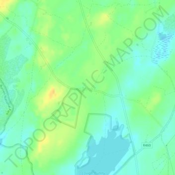
Name: Topografische Karte Boston, Höhe, Relief.
Durchschnittliche Höhe: 25 m
Minimale Höhe: 14 m
Maximale Höhe: 42 m
Andere topografische Karten
Klicken Sie auf eine Karte, um ihre Topografie, ihre Höhe und ihr Relief anzuzeigen.
Kilmihil
Kilmihil, West Clare Municipal District, County Clare, Munster, Ireland
Durchschnittliche Höhe: 69 m
Killaloe
Killaloe, Killaloe ED, Killaloe Municipal District, County Clare, Munster, Ireland
Durchschnittliche Höhe: 62 m
Killaloe Municipal District
Killaloe Municipal District, County Clare, Munster, Ireland
Durchschnittliche Höhe: 85 m
Knock
Knock, Knock ED, West Clare Municipal District, County Clare, Munster, Ireland
Durchschnittliche Höhe: 21 m
Cliffs of Moher
Cliffs of Moher, Ballysteen ED, West Clare Municipal District, County Clare, Munster, Ireland
Durchschnittliche Höhe: 55 m
Kilrush
Kilrush, Kilrush Urban ED, West Clare Municipal District, County Clare, Munster, Ireland
Durchschnittliche Höhe: 24 m
Kilkee Cliffs
Kilkee Cliffs, Cliff Walk, Kilkee ED, West Clare Municipal District, County Clare, Munster, Ireland
Durchschnittliche Höhe: 19 m
Saint Thomas Island
Saint Thomas Island, Ballyglass ED, Shannon Municipal District, County Clare, Munster, Ireland
Durchschnittliche Höhe: 10 m
West Clare Municipal District
West Clare Municipal District, County Clare, Munster, Ireland
Durchschnittliche Höhe: 37 m
Coor
Coor, Ennis Rural ED, Ennis Municipal District, County Clare, Munster, Ireland
Durchschnittliche Höhe: 32 m
Carran
Ireland > County Clare > Carran
Carran, Carran ED, West Clare Municipal District, County Clare, Munster, Ireland
Durchschnittliche Höhe: 154 m
Abbey Hill
Abbey Hill, West Clare Municipal District, County Clare, Munster, H91 DFH7, Ireland
Durchschnittliche Höhe: 67 m
Ennis Municipal District
Ennis Municipal District, County Clare, Munster, Ireland
Durchschnittliche Höhe: 39 m
Rine River
Rine River, Doora ED, Ennis Municipal District, County Clare, Munster, Ireland
Durchschnittliche Höhe: 6 m
Tulla
Tulla, Killaloe Municipal District, County Clare, Munster, Ireland
Durchschnittliche Höhe: 49 m
Broadford
Broadford, Kilseily ED, Killaloe Municipal District, County Clare, Munster, Ireland
Durchschnittliche Höhe: 95 m