
Topografische Karte Abbey Hill
Interaktive Karte
Klicken Sie auf die Karte, um die Höhe anzuzeigen.
Über diese Karte
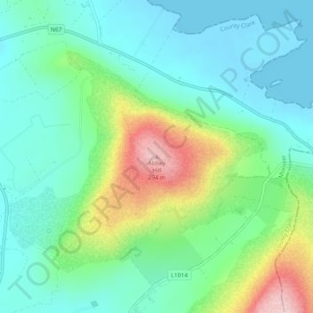
Name: Topografische Karte Abbey Hill, Höhe, Relief.
Durchschnittliche Höhe: 67 m
Minimale Höhe: -3 m
Maximale Höhe: 239 m
Andere topografische Karten
Klicken Sie auf eine Karte, um ihre Topografie, ihre Höhe und ihr Relief anzuzeigen.
Mullaghmore
Mullaghmore, West Clare Municipal District, County Clare, Munster, H91 R9FX, Ireland
Durchschnittliche Höhe: 61 m
Boston
Boston, Boston ED, West Clare Municipal District, County Clare, Munster, H91 R9FX, Ireland
Durchschnittliche Höhe: 25 m
Kilmihil
Kilmihil, West Clare Municipal District, County Clare, Munster, Ireland
Durchschnittliche Höhe: 69 m
Killaloe
Killaloe, Killaloe ED, Killaloe Municipal District, County Clare, Munster, Ireland
Durchschnittliche Höhe: 62 m
Killaloe Municipal District
Killaloe Municipal District, County Clare, Munster, Ireland
Durchschnittliche Höhe: 85 m
Knock
Knock, Knock ED, West Clare Municipal District, County Clare, Munster, Ireland
Durchschnittliche Höhe: 21 m
Cliffs of Moher
Cliffs of Moher, Ballysteen ED, West Clare Municipal District, County Clare, Munster, Ireland
Durchschnittliche Höhe: 55 m
Kilrush
Kilrush, Kilrush Urban ED, West Clare Municipal District, County Clare, Munster, Ireland
Durchschnittliche Höhe: 24 m
Kilkee Cliffs
Kilkee Cliffs, Cliff Walk, Kilkee ED, West Clare Municipal District, County Clare, Munster, Ireland
Durchschnittliche Höhe: 19 m
Saint Thomas Island
Saint Thomas Island, Ballyglass ED, Shannon Municipal District, County Clare, Munster, Ireland
Durchschnittliche Höhe: 10 m
West Clare Municipal District
West Clare Municipal District, County Clare, Munster, Ireland
Durchschnittliche Höhe: 37 m
Coor
Coor, Ennis Rural ED, Ennis Municipal District, County Clare, Munster, Ireland
Durchschnittliche Höhe: 32 m
Carran
Ireland > County Clare > Carran
Carran, Carran ED, West Clare Municipal District, County Clare, Munster, Ireland
Durchschnittliche Höhe: 154 m
Ennis Municipal District
Ennis Municipal District, County Clare, Munster, Ireland
Durchschnittliche Höhe: 39 m
Rine River
Rine River, Doora ED, Ennis Municipal District, County Clare, Munster, Ireland
Durchschnittliche Höhe: 6 m
Tulla
Tulla, Killaloe Municipal District, County Clare, Munster, Ireland
Durchschnittliche Höhe: 49 m
Broadford
Broadford, Kilseily ED, Killaloe Municipal District, County Clare, Munster, Ireland
Durchschnittliche Höhe: 95 m