
Topografische Karte Woodford Halse
Interaktive Karte
Klicken Sie auf die Karte, um die Höhe anzuzeigen.
Über diese Karte
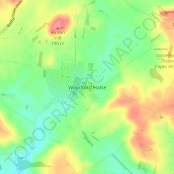
Name: Topografische Karte Woodford Halse, Höhe, Relief.
Durchschnittliche Höhe: 154 m
Minimale Höhe: 122 m
Maximale Höhe: 200 m
Andere topografische Karten
Klicken Sie auf eine Karte, um ihre Topografie, ihre Höhe und ihr Relief anzuzeigen.
Chapel Brampton
United Kingdom > England > West Northamptonshire
Chapel Brampton, West Northamptonshire, England, NN6 8AF, United Kingdom
Durchschnittliche Höhe: 91 m
Silverstone
United Kingdom > England > West Northamptonshire
Silverstone, West Northamptonshire, England, United Kingdom
Durchschnittliche Höhe: 133 m
Bradden
United Kingdom > England > West Northamptonshire
Bradden, West Northamptonshire, England, United Kingdom
Durchschnittliche Höhe: 118 m
Astcote
United Kingdom > England > West Northamptonshire
Astcote, Pattishall, West Northamptonshire, England, NN12 8NR, United Kingdom
Durchschnittliche Höhe: 129 m
Pury End
United Kingdom > England > West Northamptonshire > Paulerspury
Pury End, Paulerspury, West Northamptonshire, England, NN12 7NX, United Kingdom
Durchschnittliche Höhe: 120 m
West Hunsbury
United Kingdom > England > West Northamptonshire
West Hunsbury, West Northamptonshire, England, United Kingdom
Durchschnittliche Höhe: 78 m