
Topografische Karte Silverstone
Interaktive Karte
Klicken Sie auf die Karte, um die Höhe anzuzeigen.
Über diese Karte
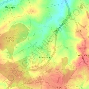
Name: Topografische Karte Silverstone, Höhe, Relief.
Ort: Silverstone, West Northamptonshire, England, United Kingdom (52.07159 -1.05758 52.11693 -0.99845)
Durchschnittliche Höhe: 133 m
Minimale Höhe: 94 m
Maximale Höhe: 166 m
Andere topografische Karten
Klicken Sie auf eine Karte, um ihre Topografie, ihre Höhe und ihr Relief anzuzeigen.
Woodford Halse
United Kingdom > England > West Northamptonshire
Woodford Halse, West Northamptonshire, England, NN11 3NS, United Kingdom
Durchschnittliche Höhe: 154 m
Chapel Brampton
United Kingdom > England > West Northamptonshire
Chapel Brampton, West Northamptonshire, England, NN6 8AF, United Kingdom
Durchschnittliche Höhe: 91 m
Bradden
United Kingdom > England > West Northamptonshire
Bradden, West Northamptonshire, England, United Kingdom
Durchschnittliche Höhe: 118 m
Astcote
United Kingdom > England > West Northamptonshire
Astcote, Pattishall, West Northamptonshire, England, NN12 8NR, United Kingdom
Durchschnittliche Höhe: 129 m
Pury End
United Kingdom > England > West Northamptonshire > Paulerspury
Pury End, Paulerspury, West Northamptonshire, England, NN12 7NX, United Kingdom
Durchschnittliche Höhe: 120 m
West Hunsbury
United Kingdom > England > West Northamptonshire
West Hunsbury, West Northamptonshire, England, United Kingdom
Durchschnittliche Höhe: 78 m