
Topografische Karte Concrete
Interaktive Karte
Klicken Sie auf die Karte, um die Höhe anzuzeigen.
Über diese Karte
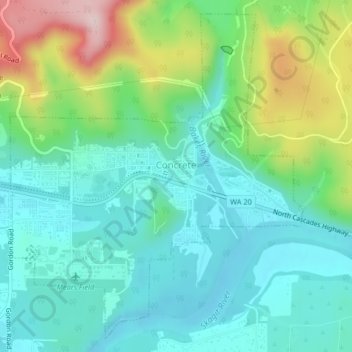
Name: Topografische Karte Concrete, Höhe, Relief.
Ort: Concrete, Skagit County, Washington, United States (48.52557 -121.76615 48.55053 -121.73227)
Durchschnittliche Höhe: 125 m
Minimale Höhe: 42 m
Maximale Höhe: 341 m
Mears Field (3W5), formerly known as Concrete Municipal Airport, is located one mile south of Concrete at an elevation of 267 ft MSL.
Andere topografische Karten
Klicken Sie auf eine Karte, um ihre Topografie, ihre Höhe und ihr Relief anzuzeigen.
Mount Erie
United States > Washington > Skagit County > Anacortes
Mount Erie, Anacortes, Skagit County, Washington, 98221, United States
Durchschnittliche Höhe: 128 m
Marblemount
United States > Washington > Skagit County
Marblemount, Skagit County, Washington, United States
Durchschnittliche Höhe: 249 m
Big Lake
United States > Washington > Skagit County
Big Lake, Skagit County, Washington, 98274, United States
Durchschnittliche Höhe: 80 m
Anacortes
United States > Washington > Skagit County
Anacortes, Skagit County, Washington, 98221, United States
Durchschnittliche Höhe: 36 m
Anacortes
United States > Washington > Skagit County > Anacortes > Anacortes
Anacortes, Skagit County, Washington, 98221, United States
Durchschnittliche Höhe: 37 m
Coal Mountain
United States > Washington > Skagit County
Coal Mountain, Skagit County, Washington, United States
Durchschnittliche Höhe: 1.003 m
Sedro-Woolley
United States > Washington > Skagit County
Sedro-Woolley, Skagit County, Washington, United States
Durchschnittliche Höhe: 28 m
Burlington
United States > Washington > Skagit County
Burlington, Skagit County, Washington, 98233, United States
Durchschnittliche Höhe: 12 m
Mount Vernon
United States > Washington > Skagit County
Mount Vernon, Skagit County, Washington, 98273, United States
Durchschnittliche Höhe: 37 m