
Topografische Karte Sedro-Woolley
Interaktive Karte
Klicken Sie auf die Karte, um die Höhe anzuzeigen.
Über diese Karte
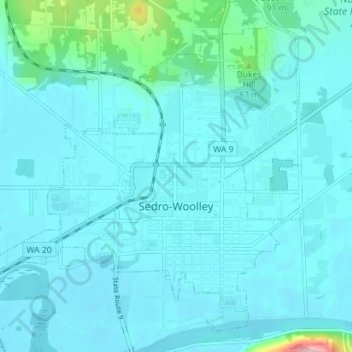
Name: Topografische Karte Sedro-Woolley, Höhe, Relief.
Ort: Sedro-Woolley, Skagit County, Washington, United States (48.48828 -122.28041 48.52960 -122.20984)
Durchschnittliche Höhe: 28 m
Minimale Höhe: 8 m
Maximale Höhe: 220 m
Andere topografische Karten
Klicken Sie auf eine Karte, um ihre Topografie, ihre Höhe und ihr Relief anzuzeigen.
Mount Erie
United States > Washington > Skagit County > Anacortes
Mount Erie, Anacortes, Skagit County, Washington, 98221, United States
Durchschnittliche Höhe: 128 m
Marblemount
United States > Washington > Skagit County
Marblemount, Skagit County, Washington, United States
Durchschnittliche Höhe: 249 m
Big Lake
United States > Washington > Skagit County
Big Lake, Skagit County, Washington, 98274, United States
Durchschnittliche Höhe: 80 m
Anacortes
United States > Washington > Skagit County
Anacortes, Skagit County, Washington, 98221, United States
Durchschnittliche Höhe: 36 m
Anacortes
United States > Washington > Skagit County > Anacortes > Anacortes
Anacortes, Skagit County, Washington, 98221, United States
Durchschnittliche Höhe: 37 m
Concrete
United States > Washington > Skagit County
Concrete, Skagit County, Washington, United States
Durchschnittliche Höhe: 125 m
Coal Mountain
United States > Washington > Skagit County
Coal Mountain, Skagit County, Washington, United States
Durchschnittliche Höhe: 1.003 m
Burlington
United States > Washington > Skagit County
Burlington, Skagit County, Washington, 98233, United States
Durchschnittliche Höhe: 12 m
Mount Vernon
United States > Washington > Skagit County
Mount Vernon, Skagit County, Washington, 98273, United States
Durchschnittliche Höhe: 37 m