
Topografische Karte Manila
Interaktive Karte
Klicken Sie auf die Karte, um die Höhe anzuzeigen.
Über diese Karte
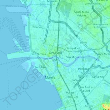
Name: Topografische Karte Manila, Höhe, Relief.
Ort: Manila, Metro Manila, Philippines (14.55418 120.94169 14.63900 121.02617)
Durchschnittliche Höhe: 6 m
Minimale Höhe: -1 m
Maximale Höhe: 68 m
Almost all of Manila sits on top of centuries of prehistoric alluvial deposits built by the waters of the Pasig River and on some land reclaimed from Manila Bay. Manila's land has been altered substantially by human intervention, with considerable land reclamation along the waterfronts since the American colonial times. Some of the city's natural variations in topography have been evened out. As of 2013, Manila had a total area of 42.88 square kilometers.
Andere topografische Karten
Klicken Sie auf eine Karte, um ihre Topografie, ihre Höhe und ihr Relief anzuzeigen.
Sampaloc
Sampaloc, Fourth District, Manila, Capital District, Metro Manila, Philippines
Durchschnittliche Höhe: 9 m
Tondo
Tondo, 1st District, Manila, Capital District, Metro Manila, 1012, Philippines
Durchschnittliche Höhe: 5 m
Santa Mesa
Santa Mesa, Sixth District, Manila, Capital District, Metro Manila, Philippines
Durchschnittliche Höhe: 9 m
Barangay 469
Barangay 469, Manila, 4th District, Manila, Metro Manila, Philippines
Durchschnittliche Höhe: 8 m