
Topografische Karte Parque Parana
Interaktive Karte
Klicken Sie auf die Karte, um die Höhe anzuzeigen.
Über diese Karte
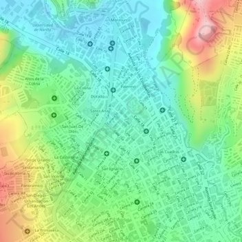
Name: Topografische Karte Parque Parana, Höhe, Relief.
Ort: Parque Parana, Maridíaz, Pasto, Nariño, Colombia (1.22161 -77.28504 1.22252 -77.28420)
Durchschnittliche Höhe: 2.553 m
Minimale Höhe: 2.472 m
Maximale Höhe: 2.705 m
Andere topografische Karten
Klicken Sie auf eine Karte, um ihre Topografie, ihre Höhe und ihr Relief anzuzeigen.