
Topografische Karte Village of Richfield
Interaktive Karte
Klicken Sie auf die Karte, um die Höhe anzuzeigen.
Über diese Karte
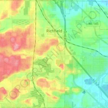
Name: Topografische Karte Village of Richfield, Höhe, Relief.
Durchschnittliche Höhe: 296 m
Minimale Höhe: 254 m
Maximale Höhe: 364 m
According to the United States Census Bureau, the village has a total area of 36.46 square miles (94.43 km2), of which, 35.91 square miles (93.01 km2) of it is land and 0.55 square miles (1.42 km2) is water. The low point in the village lies in Section 1 at Little Cedar Creek with an elevation of 856 feet. The high point in the village lies in Section 19 in the Cul-de-sac of Cheyenne Court at an elevation of 1,174 feet. (Washington County, Wi 2foot topography)
Andere topografische Karten
Klicken Sie auf eine Karte, um ihre Topografie, ihre Höhe und ihr Relief anzuzeigen.
West Bend
United States > Wisconsin > Washington County
West Bend, Washington County, Wisconsin, United States
Durchschnittliche Höhe: 298 m
Town of Addison
United States > Wisconsin > Washington County
Town of Addison, Washington County, Wisconsin, 53002, United States
Durchschnittliche Höhe: 318 m
Town of Polk
United States > Wisconsin > Washington County
Town of Polk, Washington County, Wisconsin, 53086, United States
Durchschnittliche Höhe: 305 m
Slinger
United States > Wisconsin > Washington County
Slinger, Washington County, Wisconsin, United States
Durchschnittliche Höhe: 331 m
Hartford
United States > Wisconsin > Washington County
Hartford, Washington County, Wisconsin, 53027, United States
Durchschnittliche Höhe: 313 m
Village of Germantown
United States > Wisconsin > Washington County
Village of Germantown, Washington County, Wisconsin, United States
Durchschnittliche Höhe: 267 m
Allenton
United States > Wisconsin > Washington County > Allenton
Allenton, Washington County, Wisconsin, 53002-9800, United States
Durchschnittliche Höhe: 313 m
Kewaskum
United States > Wisconsin > Washington County
Kewaskum, Washington County, Wisconsin, United States
Durchschnittliche Höhe: 295 m