Geolokalisieren

Topografische Karte Damortis

Interaktive Karte

Klicken Sie auf die Karte, um die Höhe anzuzeigen.

Über diese Karte

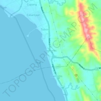
Name: Topografische Karte Damortis, Höhe, Relief.

Ort: Damortis, Santo Tomas, La Union, Philippines (16.22250 120.38489 16.26250 120.42489)

Durchschnittliche Höhe: 25 m

Minimale Höhe: -1 m

Maximale Höhe: 154 m

Andere topografische Karten

Klicken Sie auf eine Karte, um ihre Topografie, ihre Höhe und ihr Relief anzuzeigen.

Sungyot Island

Philippines > La Union > Santo Tomas

Sungyot Island, Santo Tomas, La Union, Ilocos Region, Philippines

Durchschnittliche Höhe: 0 m

Cupang

Philippines > La Union > Santo Tomas

Cupang, Santo Tomas, La Union, Ilocos Region, Philippines

Durchschnittliche Höhe: 23 m

Tubod

Philippines > La Union > Santo Tomas

Tubod, Santo Tomas, La Union, Ilocos Region, Philippines

Durchschnittliche Höhe: 24 m

Agoo-Damortis Protected Landscape and Seascape

Philippines > La Union > Santo Tomas

Agoo-Damortis Protected Landscape and Seascape, Santo Tomas, La Union, Ilocos Region, Philippines

Durchschnittliche Höhe: 9 m

Parasapas

Philippines > La Union > Santo Tomas

Parasapas, Santo Tomas, La Union, Ilocos Region, 2508, Philippines

Durchschnittliche Höhe: 202 m

Santo Tomas

Philippines > La Union > Santo Tomas

Santo Tomas, La Union, Ilocos Region, 2505, Philippines

Durchschnittliche Höhe: 40 m