
Topografische Karte Chubut Province
Interaktive Karte
Klicken Sie auf die Karte, um die Höhe anzuzeigen.
Über diese Karte
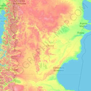
Name: Topografische Karte Chubut Province, Höhe, Relief.
Ort: Chubut Province, Argentina (-46.00002 -72.18782 -41.99203 -63.31159)
Durchschnittliche Höhe: 556 m
Minimale Höhe: 0 m
Maximale Höhe: 3.110 m
Chubut stretches from the Atlantic to the Andes with 3 distinct environmental regions: The Andes, the central plains and the coastal regions. The Andes in the westernmost parts of the province mostly extend along the Chilean border. The Andes are not that high in Chubut, with most peaks averaging around 1,500 and 2,000 metres (4,900 and 6,600 ft), which becomes smaller in altitude in the southern parts. The highest peak is Cerro Dos Picos, located east of Lago Cholila with a height of 2,515 metres (8,251 ft). The Andes in this province are of tertiary origin and are separated by wide, deep transverse valleys that are oriented in an east–west direction. These valleys are occupied by glacial lakes and rivers flowing east from the mountains. Most of these valleys existed before the Andes were formed. The lakes, which are mostly located in the western parts of the province are of glacial origin because during the last ice age, the movement of the glaciers lead to the formation of extensive areas of depressions that were filled up with water to form the lakes today.
Andere topografische Karten
Klicken Sie auf eine Karte, um ihre Topografie, ihre Höhe und ihr Relief anzuzeigen.
Cordillera Blanca
Cordillera Blanca, Municipio de Las Ovejas, Departamento Minas, Neuquén Province, Argentina
Durchschnittliche Höhe: 1.926 m
Villa Los Aromos
Argentina > Córdoba > Pedanía Alta Gracia
Villa Los Aromos, Comuna de Villa Los Aromos, Pedanía Alta Gracia, Departamento Santa María, Córdoba, X5186, Argentina
Durchschnittliche Höhe: 533 m
Villa María
Argentina > Córdoba > Pedanía Villa María
Villa María, Municipio de Villa María, Pedanía Villa María, Departamento General San Martín, Córdoba, X5900, Argentina
Durchschnittliche Höhe: 201 m
San Antonio de Areco
San Antonio de Areco, Partido de San Antonio de Areco, Buenos Aires, Argentina
Durchschnittliche Höhe: 31 m
San Juan
Argentina > Entre Ríos Province > Distrito Suburbios > Concordia
San Juan, Concordia, Distrito Suburbios, Departamento Concordia, Entre Ríos Province, Argentina
Durchschnittliche Höhe: 41 m
Autonomous City of Buenos Aires
Autonomous City of Buenos Aires, Argentina
Durchschnittliche Höhe: 14 m
5M
5M, Laguna, Chocón Medio, Departamento Picún Leufú, Neuquén Province, Argentina
Durchschnittliche Höhe: 384 m
Libertad
Libertad, Partido de Merlo, Buenos Aires, 1716, Argentina
Durchschnittliche Höhe: 27 m
Villa Cristina
Villa Cristina, Makallé, Municipio de Makallé, Departamento General Dónovan, Chaco, Argentina
Durchschnittliche Höhe: 63 m
Mariano Acosta
Mariano Acosta, Partido de Merlo, Buenos Aires, Argentina
Durchschnittliche Höhe: 25 m
El Palomar
El Palomar, Partido de Morón, Buenos Aires, Argentina
Durchschnittliche Höhe: 24 m
Nueva Italia
Argentina > Córdoba > Pedanía Capital > Cordoba
Nueva Italia, Cordoba, Municipio de Córdoba, Pedanía Capital, Departamento Capital, Córdoba, X5012, Argentina
Durchschnittliche Höhe: 415 m
Laguna del Carbón
Argentina > Santa Cruz Province
Laguna del Carbón, Corpen Aike, Santa Cruz Province, Argentina
Durchschnittliche Höhe: -102 m
Puerto Madero
Argentina > Autonomous City of Buenos Aires > Buenos Aires
Puerto Madero, Buenos Aires, Comuna 1, Autonomous City of Buenos Aires, Argentina
Durchschnittliche Höhe: 12 m
Universidad
Universidad, Partido de Luján, Buenos Aires, Argentina
Durchschnittliche Höhe: 30 m
Padre Mugica
Argentina > San Luis > San Luis
Padre Mugica, San Luis, Juan Martín de Pueyrredón, San Luis, Argentina
Durchschnittliche Höhe: 741 m
Luján
Luján, Partido de Luján, Buenos Aires, 6700, Argentina
Durchschnittliche Höhe: 30 m
Mesa
Argentina > Santa Cruz Province
Mesa, Lago Buenos Aires, Santa Cruz Province, Argentina
Durchschnittliche Höhe: 475 m
Valeria del Mar
Argentina > Buenos Aires > Valeria del Mar
Valeria del Mar, Partido de Pinamar, Buenos Aires, 7167, Argentina
Durchschnittliche Höhe: 7 m
Pellegrini Lake
Argentina > Río Negro Province
Pellegrini Lake, Departamento General Roca, Río Negro Province, Argentina
Durchschnittliche Höhe: 287 m
Parque Lago
Argentina > Buenos Aires > Mar de Cobo > Parque Lago
Parque Lago, Mar de Cobo, Partido de Mar Chiquita, Buenos Aires, 7609, Argentina
Durchschnittliche Höhe: 2 m
Río Cuarto
Argentina > Córdoba > Río Cuarto
Río Cuarto, Municipio de Río Cuarto, Pedanía Río Cuarto, Departamento Río Cuarto, Córdoba, X5800, Argentina
Durchschnittliche Höhe: 443 m
Riverland
Argentina > Buenos Aires > San Nicolás de los Arroyos
Riverland, San Nicolás de los Arroyos, Partido de San Nicolás, Buenos Aires, Argentina
Durchschnittliche Höhe: 16 m
Pilar
Pilar, Partido del Pilar, Buenos Aires, Argentina
Durchschnittliche Höhe: 19 m
Pergamino
Argentina > Buenos Aires > Pergamino
Pergamino, Partido de Pergamino, Buenos Aires, 2700, Argentina
Durchschnittliche Höhe: 72 m
Haedo
Argentina > Buenos Aires > Haedo
Haedo, Partido de Morón, Buenos Aires, 1706, Argentina
Durchschnittliche Höhe: 28 m
Municipio de Villa Gobernador Gálvez
Municipio de Villa Gobernador Gálvez, Departamento Rosario, Santa Fe, S2124, Argentina
Durchschnittliche Höhe: 25 m
Belgrano
Argentina > Autonomous City of Buenos Aires > Autonomous City of Buenos Aires
Belgrano, Autonomous City of Buenos Aires, Argentina
Durchschnittliche Höhe: 13 m
Cerro Aconcagua
Cerro Aconcagua, Distrito Las Cuevas, Departamento Las Heras, Mza., Argentina
Durchschnittliche Höhe: 6.197 m
Parque San Martín
Argentina > Buenos Aires > Parque San Martín
Parque San Martín, Partido de Merlo, Buenos Aires, Argentina
Durchschnittliche Höhe: 24 m
San Rafael
Argentina > Mza. > San Rafael
San Rafael, Distrito Ciudad de San Rafael, Departamento San Rafael, Mza., 5602, Argentina
Durchschnittliche Höhe: 701 m
Magallanes
Argentina > Santa Cruz Province, Argentina
Magallanes, Santa Cruz Province, Argentina, Argentina
Durchschnittliche Höhe: 244 m
El Calafate
Argentina > Santa Cruz Province, Argentina > El Calafate
El Calafate, Lago Argentino, Santa Cruz Province, Argentina, 9405, Argentina
Durchschnittliche Höhe: 296 m
Olavarría
Argentina > Buenos Aires > Olavarría
Olavarría, Partido de Olavarría, Buenos Aires, Argentina
Durchschnittliche Höhe: 167 m
Puerta Tastil
Argentina > Salta > Puerta Tastil
Puerta Tastil, Municipio de Campo Quijano, Rosario de Lerma, Salta, Argentina
Durchschnittliche Höhe: 2.798 m
Guernica
Argentina > Buenos Aires > Guernica
Guernica, Partido de Presidente Perón, Buenos Aires, 1862, Argentina
Durchschnittliche Höhe: 28 m
Municipio de Villa de las Rosas
Municipio de Villa de las Rosas, Pedanía Rosas, Departamento San Javier, Córdoba, X5870, Argentina
Durchschnittliche Höhe: 899 m