Topografische Karte Cassel
Interaktive Karte
Klicken Sie auf die Karte, um die Höhe anzuzeigen.
Über diese Karte
![Topografische Karte Cassel, Höhe, Relief](/pub/maps/node/f2z4/9mj7m3l/thumbnail.jpg)
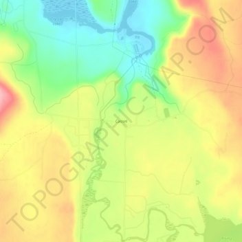
Name: Topografische Karte Cassel, Höhe, Relief.
Ort: Cassel, Shasta County, California, 96016, United States (40.89905 -121.56776 40.93905 -121.52776)
Durchschnittliche Höhe: 972 m
Minimale Höhe: 905 m
Maximale Höhe: 1.040 m
Cassel is a census-designated place (CDP) in Shasta County, California. Cassel sits at an elevation of 3,176 feet (968 m). Its population is 207 as of the 2020 census, remaining the same from the 2010 census. The ZIP Code is 96016. The community is inside area code 530.
Andere topografische Karten
Klicken Sie auf eine Karte, um ihre Topografie, ihre Höhe und ihr Relief anzuzeigen.
![Topografische Karte Seven Lakes Basin, Höhe, Relief](/pub/maps/node/xgtf/qmz15xtf/icon.jpg)
Seven Lakes Basin
United States > California > Shasta County
Seven Lakes Basin, Shasta County, California, United States
Durchschnittliche Höhe: 1.964 m
![Topografische Karte Eskimo Hill, Höhe, Relief](/pub/maps/node/nd3q/kdm5km2/icon.jpg)
Eskimo Hill
United States > California > Shasta County
Eskimo Hill, Shasta County, California, United States
Durchschnittliche Höhe: 1.843 m
![Topografische Karte Viola, Höhe, Relief](/pub/maps/node/59t6/6pwnxs8/icon.jpg)
Viola
United States > California > Shasta County
Viola, Shasta County, California, United States
Durchschnittliche Höhe: 1.371 m
![Topografische Karte Old Station, Höhe, Relief](/pub/maps/node/233q/9m5vn3l/icon.jpg)
Old Station
United States > California > Shasta County
Old Station, Shasta County, California, 96071, United States
Durchschnittliche Höhe: 1.383 m
![Topografische Karte Turquoise Pool, Höhe, Relief](/pub/maps/way/l351/sgqhbz4/icon.jpg)
Turquoise Pool
United States > California > Shasta County
Turquoise Pool, Bumpass Hell Boardwalk, Shasta County, California, United States
Durchschnittliche Höhe: 2.406 m
![Topografische Karte Lake Britton, Höhe, Relief](/pub/maps/relation/gwzs/vzdz51/icon.jpg)
Lake Britton
United States > California > Shasta County
Lake Britton, Shasta County, California, United States
Durchschnittliche Höhe: 939 m
![Topografische Karte Sherman, Höhe, Relief](/pub/maps/node/7f9m/fn91914/icon.jpg)
Sherman
United States > California > Shasta County
Sherman, Shasta County, California, United States
Durchschnittliche Höhe: 370 m
![Topografische Karte Redding, Höhe, Relief](/pub/maps/relation/z5tj/dcnb3/icon.jpg)
Redding
United States > California > Shasta County
Redding, Shasta County, California, United States
Durchschnittliche Höhe: 240 m
![Topografische Karte Platina, Höhe, Relief](/pub/maps/node/kjs8/dtwdz9m/icon.jpg)
Platina
United States > California > Shasta County
Platina, Shasta County, California, 96076, United States
Durchschnittliche Höhe: 770 m
![Topografische Karte Burney, Höhe, Relief](/pub/maps/node/lsmt/7hb7wb3/icon.jpg)
Burney
United States > California > Shasta County
Burney, Shasta County, California, 96013, United States
Durchschnittliche Höhe: 989 m
![Topografische Karte Bella Vista, Höhe, Relief](/pub/maps/node/k6b3/x8q9gtf/icon.jpg)
Bella Vista
United States > California > Shasta County
Bella Vista, Shasta County, California, 96008, United States
Durchschnittliche Höhe: 188 m
![Topografische Karte Redding, Höhe, Relief](/pub/maps/node/kjf3/8r6mwdn/icon.jpg)
Redding
United States > California > Shasta County > Redding
Redding, Shasta County, California, 96049-6073, United States
Durchschnittliche Höhe: 312 m
![Topografische Karte Shingletown, Höhe, Relief](/pub/maps/relation/g3nx/lx76cz/icon.jpg)
Shingletown
United States > California > Shasta County
Shingletown, Shasta County, California, United States
Durchschnittliche Höhe: 920 m
![Topografische Karte Lakehead, Höhe, Relief](/pub/maps/node/lmgt/5frrv5k/icon.jpg)
Lakehead
United States > California > Shasta County
Lakehead, Shasta County, California, 96051, United States
Durchschnittliche Höhe: 407 m
![Topografische Karte Montgomery Creek, Höhe, Relief](/pub/maps/way/7k1h/pgv3fgt/icon.jpg)
Montgomery Creek
United States > California > Shasta County
Montgomery Creek, Shasta County, California, United States
Durchschnittliche Höhe: 742 m
![Topografische Karte McArthur, Höhe, Relief](/pub/maps/relation/3r51/w9bbb3/icon.jpg)
McArthur
United States > California > Shasta County
McArthur, Shasta County, California, 96056, United States
Durchschnittliche Höhe: 1.004 m
![Topografische Karte Shingletown, Höhe, Relief](/pub/maps/relation/6h3l/gz37tp/icon.jpg)
Shingletown
United States > California > Shasta County
Shingletown, Shasta County, California, 96088, United States
Durchschnittliche Höhe: 920 m
![Topografische Karte Centerville, Höhe, Relief](/pub/maps/node/pzmt/7hg8hb3/icon.jpg)
Centerville
United States > California > Shasta County
Centerville, Shasta County, California, United States
Durchschnittliche Höhe: 289 m
![Topografische Karte Shasta Lake, Höhe, Relief](/pub/maps/relation/8z14/9qbwdn/icon.jpg)
Shasta Lake
United States > California > Shasta County
Shasta Lake, Shasta County, California, United States
Durchschnittliche Höhe: 265 m
![Topografische Karte Shasta Lake, Höhe, Relief](/pub/maps/way/zttj/1kjv2m2/icon.jpg)
Shasta Lake
United States > California > Shasta County
Shasta Lake, Shasta County, California, United States
Durchschnittliche Höhe: 281 m
![Topografische Karte Palo Cedro, Höhe, Relief](/pub/maps/relation/7bs8/b2vkz4/icon.jpg)
Palo Cedro
United States > California > Shasta County > Palo Cedro
Palo Cedro, Shasta County, California, 96073, United States
Durchschnittliche Höhe: 157 m
![Topografische Karte Ward Butte, Höhe, Relief](/pub/maps/node/g63l/z5kps18/icon.jpg)
Ward Butte
United States > California > Shasta County
Ward Butte, Shasta County, California, United States
Durchschnittliche Höhe: 1.390 m
![Topografische Karte Anderson, Höhe, Relief](/pub/maps/relation/8pgp/wmg41h/icon.jpg)
Anderson
United States > California > Shasta County
Anderson, Shasta County, California, 96007, United States
Durchschnittliche Höhe: 148 m
![Topografische Karte Cottonwood, Höhe, Relief](/pub/maps/relation/v5rr/f9v8cz/icon.jpg)
Cottonwood
United States > California > Shasta County
Cottonwood, Shasta County, California, United States
Durchschnittliche Höhe: 140 m
![Topografische Karte Anderson, Höhe, Relief](/pub/maps/way/8l9m/qlxjxtj/icon.jpg)
Anderson
United States > California > Shasta County
Anderson, Shasta County, CAL Fire Northern Region, California, 96007, United States
Durchschnittliche Höhe: 151 m
![Topografische Karte Fall River Mills, Höhe, Relief](/pub/maps/relation/7p14/2cvvnx/icon.jpg)
Fall River Mills
United States > California > Shasta County
Fall River Mills, Shasta County, California, 96028, United States
Durchschnittliche Höhe: 1.022 m
![Topografische Karte Lassen Peak, Höhe, Relief](/pub/maps/node/h9tj/d77cqrr/icon.jpg)
Lassen Peak
United States > California > Shasta County
Lassen Peak, Shasta County, California, United States
Durchschnittliche Höhe: 2.689 m
![Topografische Karte Monarch Mountain, Höhe, Relief](/pub/maps/node/f63l/t15zr57/icon.jpg)
Monarch Mountain
United States > California > Shasta County
Monarch Mountain, Shasta County, California, 96095, United States
Durchschnittliche Höhe: 566 m