
Spenden
Rüste dich für dein nächstes Abenteuer:
Als Amazon-Partner verdient diese Website an qualifizierten Käufen, ohne zusätzliche Kosten für Sie.
Topografische Karte Anderson
Klicken Sie auf die Karte, um die Höhe anzuzeigen.
Spenden
Rüste dich für dein nächstes Abenteuer:
Als Amazon-Partner verdient diese Website an qualifizierten Käufen, ohne zusätzliche Kosten für Sie.
Über diese Karte
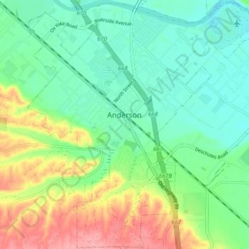
Name: Topografische Karte Anderson, Höhe, Relief.
Ort: Anderson, Shasta County, California, 96007, United States (40.41841 -122.32632 40.47363 -122.25336)
Durchschnittliche Höhe: 151 m
Minimale Höhe: 115 m
Maximale Höhe: 211 m
Spenden
Rüste dich für dein nächstes Abenteuer:
Als Amazon-Partner verdient diese Website an qualifizierten Käufen, ohne zusätzliche Kosten für Sie.
Andere topografische Karten
Klicken Sie auf eine Karte, um ihre Topografie, ihre Höhe und ihr Relief anzuzeigen.
Spenden
Rüste dich für dein nächstes Abenteuer:
Als Amazon-Partner verdient diese Website an qualifizierten Käufen, ohne zusätzliche Kosten für Sie.
Cassel
United States > California > Shasta County
Cassel is a census-designated place (CDP) in Shasta County, California. Cassel sits at an elevation of 3,176 feet (968 m). Its population is 207 as of the 2020 census, remaining the same from the 2010 census. The ZIP Code is 96016. The community is inside area code 530.
Durchschnittliche Höhe: 972 m
Shasta
United States > California > Shasta County
Shasta is a census-designated place (CDP) in Shasta County, California, United States. Shasta sits at an elevation of 843 feet (257 m). Its population is 1,043 as of the 2020 census, down from 1,771 from the 2010 census.
Durchschnittliche Höhe: 351 m
Spenden
Rüste dich für dein nächstes Abenteuer:
Als Amazon-Partner verdient diese Website an qualifizierten Käufen, ohne zusätzliche Kosten für Sie.
Palo Cedro
United States > California > Shasta County > Palo Cedro
Palo Cedro is located at 40°33′4″N 122°14′3″W / 40.55111°N 122.23417°W / 40.55111; -122.23417 (40.551091, −122.234255) at an elevation of 465 ft (143 m) above sea level.
Durchschnittliche Höhe: 157 m
Spenden
Rüste dich für dein nächstes Abenteuer:
Als Amazon-Partner verdient diese Website an qualifizierten Käufen, ohne zusätzliche Kosten für Sie.
Redding
United States > California > Shasta County > Redding
The elevation in Redding is 495 feet (151 meters) on average, whereas anywhere to the north, east, or west of downtown ranges between 550 feet (170 m) and 800 feet (240 m) feet. Southern portions range between 400 feet (120 m) and 500 feet (150 m).
Durchschnittliche Höhe: 312 m
Spenden
Rüste dich für dein nächstes Abenteuer:
Als Amazon-Partner verdient diese Website an qualifizierten Käufen, ohne zusätzliche Kosten für Sie.
Spenden
Rüste dich für dein nächstes Abenteuer:
Als Amazon-Partner verdient diese Website an qualifizierten Käufen, ohne zusätzliche Kosten für Sie.