
Topografische Karte Success
Interaktive Karte
Klicken Sie auf die Karte, um die Höhe anzuzeigen.
Über diese Karte
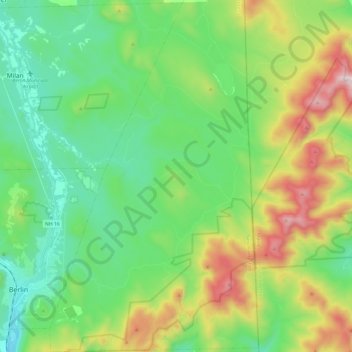
Name: Topografische Karte Success, Höhe, Relief.
Ort: Success, Coos County, New Hampshire, United States (44.43819 -71.16202 44.61030 -71.01878)
Durchschnittliche Höhe: 565 m
Minimale Höhe: 259 m
Maximale Höhe: 1.259 m
The highest point in the township is the summit of Mount Success, with an elevation of 3,565 feet (1,087 m) above sea level, in the southeast part of the township along the crest of the Mahoosucs. The Appalachian Trail follows the Mahoosuc crest across the township.
Andere topografische Karten
Klicken Sie auf eine Karte, um ihre Topografie, ihre Höhe und ihr Relief anzuzeigen.
Errol
United States > New Hampshire > Coos County
Errol, Coös County, New Hampshire, United States
Durchschnittliche Höhe: 453 m
Holden Hill
United States > New Hampshire > Coos County > Stewartstown
Holden Hill, Stewartstown, Coös County, New Hampshire, United States
Durchschnittliche Höhe: 660 m
Upper Village
United States > New Hampshire > Coos County > Gorham
Upper Village, Gorham, Coös County, New Hampshire, 03581, United States
Durchschnittliche Höhe: 343 m
Lombard Pond
United States > New Hampshire > Coos County > Colebrook
Lombard Pond, Colebrook, Coos County, New Hampshire, United States
Durchschnittliche Höhe: 402 m