
Topografische Karte Errol
Interaktive Karte
Klicken Sie auf die Karte, um die Höhe anzuzeigen.
Über diese Karte
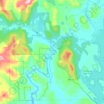
Name: Topografische Karte Errol, Höhe, Relief.
Ort: Errol, Coös County, New Hampshire, United States (44.70826 -71.21592 44.82853 -71.03441)
Durchschnittliche Höhe: 453 m
Minimale Höhe: 358 m
Maximale Höhe: 821 m
According to the United States Census Bureau, the town has a total area of 69.5 square miles (179.9 km2), of which 60.3 square miles (156.3 km2) are land and 9.1 square miles (23.5 km2) are water, comprising 13.09% of the town. The Androscoggin River begins in Errol, where the Magalloway River joins the outlet of Umbagog Lake. The town's elevation reaches 2,350 feet (720 m) above sea level atop a bump above Signal Pond near the town's western boundary. Errol lies fully within the Androscoggin River watershed.
Andere topografische Karten
Klicken Sie auf eine Karte, um ihre Topografie, ihre Höhe und ihr Relief anzuzeigen.
Holden Hill
United States > New Hampshire > Coos County > Stewartstown
Holden Hill, Stewartstown, Coös County, New Hampshire, United States
Durchschnittliche Höhe: 660 m
Upper Village
United States > New Hampshire > Coos County > Gorham
Upper Village, Gorham, Coös County, New Hampshire, 03581, United States
Durchschnittliche Höhe: 343 m
Success
United States > New Hampshire > Coos County
Success, Coos County, New Hampshire, United States
Durchschnittliche Höhe: 565 m
Lombard Pond
United States > New Hampshire > Coos County > Colebrook
Lombard Pond, Colebrook, Coos County, New Hampshire, United States
Durchschnittliche Höhe: 402 m
Mount Martha
United States > New Hampshire > Coos County > Carroll
Mount Martha, Carroll, Coös County, New Hampshire, United States
Durchschnittliche Höhe: 823 m