
Topografische Karte Dorval
Interaktive Karte
Klicken Sie auf die Karte, um die Höhe anzuzeigen.
Über diese Karte
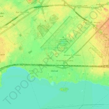
Name: Topografische Karte Dorval, Höhe, Relief.
Durchschnittliche Höhe: 29 m
Minimale Höhe: 14 m
Maximale Höhe: 48 m
Andere topografische Karten
Klicken Sie auf eine Karte, um ihre Topografie, ihre Höhe und ihr Relief anzuzeigen.
Montreal
Canada > Quebec > Urban agglomeration of Montreal
Montreal, Urban agglomeration of Montreal, Montreal (administrative region), Quebec, Canada
Durchschnittliche Höhe: 29 m
Mount Royal Park
Canada > Quebec > Urban agglomeration of Montreal > Montreal
Mount Royal Park, Ville-Marie, Montreal, Urban agglomeration of Montreal, Montreal (administrative region), Quebec, H3G 1A8, Canada
Durchschnittliche Höhe: 110 m
Parc Marie-Claire-Kirkland-Casgrain
Canada > Quebec > Urban agglomeration of Montreal > Montreal
Parc Marie-Claire-Kirkland-Casgrain, Sault-Saint-Louis, LaSalle, Montreal, Urban agglomeration of Montreal, Montreal (06), Quebec, Canada
Durchschnittliche Höhe: 24 m
Mount-Royal
Canada > Quebec > Urban agglomeration of Montreal > Montreal
Mount-Royal, Montreal, Urban agglomeration of Montreal, Montreal (06), Quebec, H3A 2B7, Canada
Durchschnittliche Höhe: 111 m
Parc-nature de la Pointe-aux-Prairies
Canada > Quebec > Urban agglomeration of Montreal > Montreal
Parc-nature de la Pointe-aux-Prairies, Rue Sherbrooke Est, Pointe-aux-Trembles, Montreal, Urban agglomeration of Montreal, Montreal (06), Quebec, H1A 3R1, Canada
Durchschnittliche Höhe: 13 m
Sainte-Anne-de-Bellevue
Canada > Quebec > Urban agglomeration of Montreal
Sainte-Anne-de-Bellevue, Urban agglomeration of Montreal, Montreal (06), Quebec, Canada
Durchschnittliche Höhe: 30 m