
Topografische Karte Colorado City
Interaktive Karte
Klicken Sie auf die Karte, um die Höhe anzuzeigen.
Über diese Karte
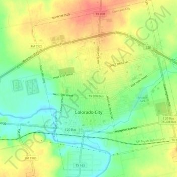
Name: Topografische Karte Colorado City, Höhe, Relief.
Durchschnittliche Höhe: 649 m
Minimale Höhe: 622 m
Maximale Höhe: 675 m
Andere topografische Karten
Klicken Sie auf eine Karte, um ihre Topografie, ihre Höhe und ihr Relief anzuzeigen.
Westbrook
United States > Texas > Mitchell County
Westbrook, Mitchell County, Texas, 79565, United States
Durchschnittliche Höhe: 657 m
Mitchell County
United States > Texas > Mitchell County
Mitchell County, Texas, United States
Durchschnittliche Höhe: 667 m
Westbrook
United States > Texas > Mitchell County > Westbrook
Westbrook, Mitchell County, Texas, 79565, United States
Durchschnittliche Höhe: 657 m
Colorado City
United States > Texas > Mitchell County > Colorado City
Colorado City, Mitchell County, Texas, United States
Durchschnittliche Höhe: 649 m