
Topografische Karte Mitchell County
Interaktive Karte
Klicken Sie auf die Karte, um die Höhe anzuzeigen.
Über diese Karte
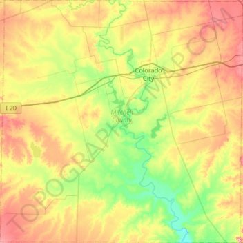
Name: Topografische Karte Mitchell County, Höhe, Relief.
Ort: Mitchell County, Texas, United States (32.08541 -101.18361 32.52803 -100.66017)
Durchschnittliche Höhe: 667 m
Minimale Höhe: 589 m
Maximale Höhe: 786 m
Andere topografische Karten
Klicken Sie auf eine Karte, um ihre Topografie, ihre Höhe und ihr Relief anzuzeigen.
Colorado City
United States > Texas > Mitchell County
Colorado City, Mitchell County, Texas, 79512, United States
Durchschnittliche Höhe: 649 m
Westbrook
United States > Texas > Mitchell County
Westbrook, Mitchell County, Texas, 79565, United States
Durchschnittliche Höhe: 657 m
Westbrook
United States > Texas > Mitchell County > Westbrook
Westbrook, Mitchell County, Texas, 79565, United States
Durchschnittliche Höhe: 657 m
Colorado City
United States > Texas > Mitchell County > Colorado City
Colorado City, Mitchell County, Texas, United States
Durchschnittliche Höhe: 649 m