
Topografische Karte Rocky Mount
Interaktive Karte
Klicken Sie auf die Karte, um die Höhe anzuzeigen.
Über diese Karte
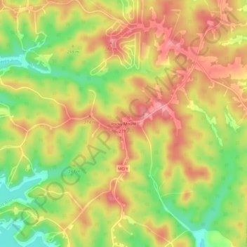
Name: Topografische Karte Rocky Mount, Höhe, Relief.
Ort: Rocky Mount, Morgan County, Missouri, 65072, United States (38.25225 -92.73963 38.29225 -92.69963)
Durchschnittliche Höhe: 246 m
Minimale Höhe: 192 m
Maximale Höhe: 286 m
Andere topografische Karten
Klicken Sie auf eine Karte, um ihre Topografie, ihre Höhe und ihr Relief anzuzeigen.
Stover
United States > Missouri > Morgan County
Stover, Morgan County, Missouri, United States
Durchschnittliche Höhe: 322 m
Barnett
United States > Missouri > Morgan County
Barnett, Morgan County, Missouri, United States
Durchschnittliche Höhe: 282 m
Laurie
United States > Missouri > Morgan County
Laurie, Morgan County, Missouri, 65038, United States
Durchschnittliche Höhe: 265 m
Boylers Mill
United States > Missouri > Morgan County
Boylers Mill, Morgan County, Missouri, United States
Durchschnittliche Höhe: 273 m
Versailles
United States > Missouri > Morgan County
Versailles, Morgan County, Missouri, 65084, United States
Durchschnittliche Höhe: 299 m
Gravois Mills
United States > Missouri > Morgan County
Gravois Mills, Morgan County, Missouri, United States
Durchschnittliche Höhe: 235 m