
Topografische Karte Boylers Mill
Interaktive Karte
Klicken Sie auf die Karte, um die Höhe anzuzeigen.
Über diese Karte
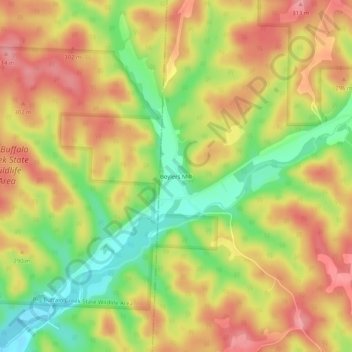
Name: Topografische Karte Boylers Mill, Höhe, Relief.
Ort: Boylers Mill, Morgan County, Missouri, United States (38.32725 -93.09075 38.36725 -93.05075)
Durchschnittliche Höhe: 273 m
Minimale Höhe: 217 m
Maximale Höhe: 315 m
Andere topografische Karten
Klicken Sie auf eine Karte, um ihre Topografie, ihre Höhe und ihr Relief anzuzeigen.
Stover
United States > Missouri > Morgan County
Stover, Morgan County, Missouri, United States
Durchschnittliche Höhe: 322 m
Barnett
United States > Missouri > Morgan County
Barnett, Morgan County, Missouri, United States
Durchschnittliche Höhe: 282 m
Laurie
United States > Missouri > Morgan County
Laurie, Morgan County, Missouri, 65038, United States
Durchschnittliche Höhe: 265 m
Rocky Mount
United States > Missouri > Morgan County
Rocky Mount, Morgan County, Missouri, 65072, United States
Durchschnittliche Höhe: 246 m
Versailles
United States > Missouri > Morgan County
Versailles, Morgan County, Missouri, 65084, United States
Durchschnittliche Höhe: 299 m
Gravois Mills
United States > Missouri > Morgan County
Gravois Mills, Morgan County, Missouri, United States
Durchschnittliche Höhe: 235 m