
Topografische Karte Saint Augustine
Interaktive Karte
Klicken Sie auf die Karte, um die Höhe anzuzeigen.
Über diese Karte
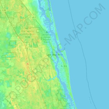
Name: Topografische Karte Saint Augustine, Höhe, Relief.
Durchschnittliche Höhe: 5 m
Minimale Höhe: -3 m
Maximale Höhe: 15 m
Andere topografische Karten
Klicken Sie auf eine Karte, um ihre Topografie, ihre Höhe und ihr Relief anzuzeigen.
Nocatee
United States > Florida > Saint Johns County
Nocatee, Saint Johns County, Florida, 32081, United States
Durchschnittliche Höhe: 7 m
Wards Creek
United States > Florida > Saint Johns County
Wards Creek, Saint Johns County, Florida, 32092, United States
Durchschnittliche Höhe: 5 m
Among Us Island
United States > Florida > Saint Johns County
Among Us Island, Saint Johns County, Florida, United States
Durchschnittliche Höhe: 10 m
Ponte Vedra Beach
United States > Florida > Saint Johns County > Ponte Vedra Beach
Ponte Vedra Beach, Saint Johns County, Florida, 32250, United States
Durchschnittliche Höhe: 3 m