
Topografische Karte Caniçal
Interaktive Karte
Klicken Sie auf die Karte, um die Höhe anzuzeigen.
Über diese Karte
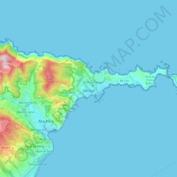
Name: Topografische Karte Caniçal, Höhe, Relief.
Ort: Caniçal, Machico, Madeira, Portugal (32.72260 -16.76570 32.75762 -16.65525)
Durchschnittliche Höhe: 72 m
Minimale Höhe: -1 m
Maximale Höhe: 724 m
Caniçal borders the municipal seat of Machico on its western frontier, and is surrounded by the Atlantic Ocean on the remaining borders. The roughly escarped terrain is prominent in the western border, where altitudes reach 800 metres above sea level and ravines are semi-active or dry year round. The urbanized and residential lands are located in a semi-gently sloping central area, while to the eastern coast, the land extends into a long narrow isthmus at Ponta de São Lourenço. Although most of the mountainous western region is forested, most of the remaining areas of the parish are populated with smaller species of herbaceous bushes, trees and pasturelands, until the Ponta de São Lourenço where vegetation is limited to sparse low-lying grasses.
Andere topografische Karten
Klicken Sie auf eine Karte, um ihre Topografie, ihre Höhe und ihr Relief anzuzeigen.
Miradouro de São Lourenço
Miradouro de São Lourenço, Ponta de São Lourenco, Caniçal, Machico, Madeira, 9200-044, Portugal
Durchschnittliche Höhe: 14 m
Porto da Cruz
Porto da Cruz, Machico, Madeira, Portugal
Durchschnittliche Höhe: 448 m