
Topografische Karte Porto da Cruz
Interaktive Karte
Klicken Sie auf die Karte, um die Höhe anzuzeigen.
Über diese Karte
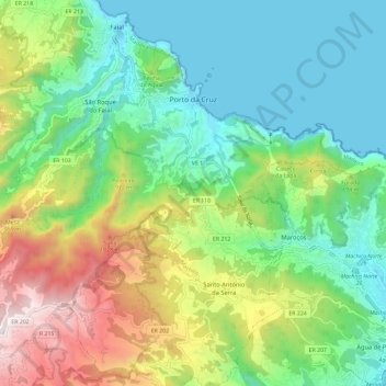
Name: Topografische Karte Porto da Cruz, Höhe, Relief.
Ort: Porto da Cruz, Machico, Madeira, Portugal (32.70993 -16.90556 32.78754 -16.78922)
Durchschnittliche Höhe: 448 m
Minimale Höhe: -2 m
Maximale Höhe: 1.409 m
The northern parish is enveloped by the mountains of Paul da Serra: Pico da Suna (1040 metres), Pico do Larano (765 metres) and Pico da Maiata (766 metres) are the highest points in the parish. Even along the coast, Penha de Águia (a mountainous escarpment 580 metres in altitude) is difficult to climb; the area, Penha da Águia, means mountain of the eagles, giving the impression that only the birds settle these lands.
Andere topografische Karten
Klicken Sie auf eine Karte, um ihre Topografie, ihre Höhe und ihr Relief anzuzeigen.