
Spenden
Rüste dich für dein nächstes Abenteuer:
Als Amazon-Partner verdient diese Website an qualifizierten Käufen, ohne zusätzliche Kosten für Sie.
Topografische Karte Tenaya Lake
Klicken Sie auf die Karte, um die Höhe anzuzeigen.
Spenden
Rüste dich für dein nächstes Abenteuer:
Als Amazon-Partner verdient diese Website an qualifizierten Käufen, ohne zusätzliche Kosten für Sie.
Tenaya Lake
Tenaya Lake is an alpine lake in Yosemite National Park, located between Yosemite Valley and Tuolumne Meadows. The surface of Tenaya Lake has an elevation of 8,150 feet (2,484 m). The lake basin was formed by glacial action, which left a backdrop of light granite rocks, whose beauty was known to the Native Americans. Today, Tenaya Lake is easily accessible by State Route 120 and is a popular lake for water activities.
Spenden
Rüste dich für dein nächstes Abenteuer:
Als Amazon-Partner verdient diese Website an qualifizierten Käufen, ohne zusätzliche Kosten für Sie.
Über diese Karte
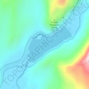
Name: Topografische Karte Tenaya Lake, Höhe, Relief.
Ort: Tenaya Lake, Mariposa County, California, United States (37.82571 -119.46821 37.83649 -119.45109)
Durchschnittliche Höhe: 2.605 m
Minimale Höhe: 2.485 m
Maximale Höhe: 3.092 m
Spenden
Rüste dich für dein nächstes Abenteuer:
Als Amazon-Partner verdient diese Website an qualifizierten Käufen, ohne zusätzliche Kosten für Sie.
Andere topografische Karten
Klicken Sie auf eine Karte, um ihre Topografie, ihre Höhe und ihr Relief anzuzeigen.
Yosemite Valley
United States > California > Mariposa County > Yosemite Village > Yosemite Lodge
Durchschnittliche Höhe: 1.479 m
Mariposa
United States > California > Mariposa County
Mariposa is located at 37°29′06″N 119°57′59″W / 37.48500°N 119.96639°W / 37.48500; -119.96639, at 1,949 feet (594 m) in elevation. It lies in the rugged foothills of the Sierra Nevada. Mariposa Creek flows through the town. Soils in the urban area are mostly brown to reddish brown loam of…
Durchschnittliche Höhe: 688 m
Spenden
Rüste dich für dein nächstes Abenteuer:
Als Amazon-Partner verdient diese Website an qualifizierten Käufen, ohne zusätzliche Kosten für Sie.
Glacier Point
United States > California > Mariposa County > Curry Village
Glacier Point is a viewpoint above Yosemite Valley in the U.S. state of California. It is located on the south wall of Yosemite Valley at an elevation of 7,214 feet (2,199 m), 3,200 feet (980 m) above Curry Village. The point offers a superb view of several of Yosemite National Park's well-known landmarks,…
Durchschnittliche Höhe: 1.711 m
Falls View
United States > California > Mariposa County > Yosemite Village > Yosemite Lodge
Durchschnittliche Höhe: 1.538 m
Spenden
Rüste dich für dein nächstes Abenteuer:
Als Amazon-Partner verdient diese Website an qualifizierten Käufen, ohne zusätzliche Kosten für Sie.
Glacier Point
United States > California > Mariposa County > Curry Village
Glacier Point is a viewpoint above Yosemite Valley in the U.S. state of California. It is located on the south wall of Yosemite Valley at an elevation of 7,214 feet (2,199 m), 3,200 feet (980 m) above Curry Village. The point offers a superb view of several of Yosemite National Park's well-known landmarks,…
Durchschnittliche Höhe: 1.775 m
Spenden
Rüste dich für dein nächstes Abenteuer:
Als Amazon-Partner verdient diese Website an qualifizierten Käufen, ohne zusätzliche Kosten für Sie.
Spenden
Rüste dich für dein nächstes Abenteuer:
Als Amazon-Partner verdient diese Website an qualifizierten Käufen, ohne zusätzliche Kosten für Sie.