

Topografische Karte Mariposa
Klicken Sie auf die Karte, um die Höhe anzuzeigen.
Mariposa
Mariposa is located at 37°29′06″N 119°57′59″W / 37.48500°N 119.96639°W / 37.48500; -119.96639, at 1,949 feet (594 m) in elevation. It lies in the rugged foothills of the Sierra Nevada. Mariposa Creek flows through the town. Soils in the urban area are mostly brown to reddish brown loam of the Blasingame series. A gravelly loam is mapped as the Boomer series. These soils support thick grassland plus trees such as blue oak, black oak, gray pine, and ponderosa pine. To the west-northwest of town is a large area of sparse vegetation and rockland on which is found serpentine soil of the Henneke series.
Über diese Karte
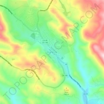
Name: Topografische Karte Mariposa, Höhe, Relief.
Durchschnittliche Höhe: 688 m
Minimale Höhe: 543 m
Maximale Höhe: 886 m
Andere topografische Karten
Klicken Sie auf eine Karte, um ihre Topografie, ihre Höhe und ihr Relief anzuzeigen.
Tenaya Lake
United States > California > Mariposa County
Tenaya Lake is an alpine lake in Yosemite National Park, located between Yosemite Valley and Tuolumne Meadows. The surface of Tenaya Lake has an elevation of 8,150 feet (2,484 m). The lake basin was formed by glacial action, which left a backdrop of light granite rocks, whose beauty was known to the Native…
Durchschnittliche Höhe: 2.605 m
Mariposa
United States > California > Mariposa County > Mariposa
Mariposa is located at 37°29′06″N 119°57′59″W / 37.48500°N 119.96639°W / 37.48500; -119.96639, at 1,949 feet (594 m) in elevation. It lies in the rugged foothills of the Sierra Nevada. Mariposa Creek flows through the town. Soils in the urban area are mostly brown to reddish brown loam of…
Durchschnittliche Höhe: 686 m