
Topografische Karte Saratoga County
Interaktive Karte
Klicken Sie auf die Karte, um die Höhe anzuzeigen.
Über diese Karte
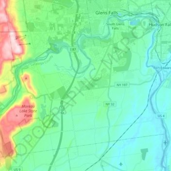
Name: Topografische Karte Saratoga County, Höhe, Relief.
Ort: Moreau, Saratoga County, New York, USA (43.19942 -73.76352 43.30709 -73.58128)
Durchschnittliche Höhe: 116 m
Minimale Höhe: 30 m
Maximale Höhe: 442 m
Andere topografische Karten
Klicken Sie auf eine Karte, um ihre Topografie, ihre Höhe und ihr Relief anzuzeigen.
Lake Champlain
Lake Champlain, Essex County, New York, USA
Durchschnittliche Höhe: 341 m
Avalanche Lake
Avalanche Lake, Avalanche Pass Trail, Essex County, New York, USA
Durchschnittliche Höhe: 1.066 m
Spike Island
Spike Island, Rye, Westchester County, New York, 10587, USA
Durchschnittliche Höhe: 50 m
Joshua
USA > New York > Town of Onondaga > Joshua
Joshua, Town of Onondaga, Onondaga County, New York, 13110, USA
Durchschnittliche Höhe: 332 m
Atlantic Basin
Atlantic Basin, New York County, New York, 11231, USA
Durchschnittliche Höhe: 4 m
Twin Mountains
Twin Mountains, Franklin County, New York, USA
Durchschnittliche Höhe: 553 m
Boundary Peak
Boundary Peak, Essex County, New York, USA
Durchschnittliche Höhe: 1.175 m
Livingston Island
Livingston Island, Town of Philipstown, Putnam County, New York, 10922, USA
Durchschnittliche Höhe: 156 m
Big Bear Mountain
Big Bear Mountain, Town of Johnsburg, Warren County, New York, USA
Durchschnittliche Höhe: 616 m
Sawtooth Mountains
Sawtooth Mountains, Franklin County, New York, USA
Durchschnittliche Höhe: 927 m
Flat Top Mountain
Flat Top Mountain, Franklin County, New York, USA
Durchschnittliche Höhe: 568 m
Mount Warren
Mount Warren, Town of Bovina, Delaware County, New York, USA
Durchschnittliche Höhe: 677 m
Roosevelt Island
USA > New York > New York City
Roosevelt Island, Manhattan Community Board 8, New York County, New York City, New York, 10044, USA
Durchschnittliche Höhe: 13 m