
Topografische Karte Mount Marcy
Interaktive Karte
Klicken Sie auf die Karte, um die Höhe anzuzeigen.
Über diese Karte
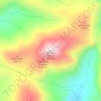
Name: Topografische Karte Mount Marcy, Höhe, Relief.
Ort: Mount Marcy, Essex County, New York, USA (44.11273 -73.92375 44.11283 -73.92365)
Durchschnittliche Höhe: 1.289 m
Minimale Höhe: 985 m
Maximale Höhe: 1.615 m
Andere topografische Karten
Klicken Sie auf eine Karte, um ihre Topografie, ihre Höhe und ihr Relief anzuzeigen.
Avalanche Lake
Avalanche Lake, Avalanche Pass Trail, Essex County, New York, USA
Durchschnittliche Höhe: 1.066 m
Spike Island
Spike Island, Rye, Westchester County, New York, 10587, USA
Durchschnittliche Höhe: 50 m
Joshua
USA > New York > Town of Onondaga > Joshua
Joshua, Town of Onondaga, Onondaga County, New York, 13110, USA
Durchschnittliche Höhe: 332 m
Atlantic Basin
Atlantic Basin, New York County, New York, 11231, USA
Durchschnittliche Höhe: 4 m
Twin Mountains
Twin Mountains, Franklin County, New York, USA
Durchschnittliche Höhe: 553 m
Lake Champlain
Lake Champlain, Essex County, New York, USA
Durchschnittliche Höhe: 341 m
Boundary Peak
Boundary Peak, Essex County, New York, USA
Durchschnittliche Höhe: 1.175 m
Livingston Island
Livingston Island, Town of Philipstown, Putnam County, New York, 10922, USA
Durchschnittliche Höhe: 156 m
Big Bear Mountain
Big Bear Mountain, Town of Johnsburg, Warren County, New York, USA
Durchschnittliche Höhe: 616 m
Sawtooth Mountains
Sawtooth Mountains, Franklin County, New York, USA
Durchschnittliche Höhe: 927 m
Flat Top Mountain
Flat Top Mountain, Franklin County, New York, USA
Durchschnittliche Höhe: 568 m
Mount Warren
Mount Warren, Town of Bovina, Delaware County, New York, USA
Durchschnittliche Höhe: 677 m
Roosevelt Island
USA > New York > New York City
Roosevelt Island, Manhattan Community Board 8, New York County, New York City, New York, 10044, USA
Durchschnittliche Höhe: 13 m