
Spenden
Rüste dich für dein nächstes Abenteuer:
Als Amazon-Partner verdient diese Website an qualifizierten Käufen, ohne zusätzliche Kosten für Sie.
Topografische Karte Stevenage
Klicken Sie auf die Karte, um die Höhe anzuzeigen.
Spenden
Rüste dich für dein nächstes Abenteuer:
Als Amazon-Partner verdient diese Website an qualifizierten Käufen, ohne zusätzliche Kosten für Sie.
Über diese Karte
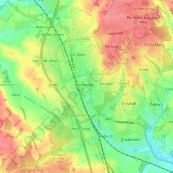
Name: Topografische Karte Stevenage, Höhe, Relief.
Ort: Stevenage, Hertfordshire, England, United Kingdom (51.86932 -0.23438 51.93243 -0.14680)
Durchschnittliche Höhe: 108 m
Minimale Höhe: 70 m
Maximale Höhe: 147 m
Spenden
Rüste dich für dein nächstes Abenteuer:
Als Amazon-Partner verdient diese Website an qualifizierten Käufen, ohne zusätzliche Kosten für Sie.
Andere topografische Karten
Klicken Sie auf eine Karte, um ihre Topografie, ihre Höhe und ihr Relief anzuzeigen.
Letchworth
United Kingdom > England > Hertfordshire > North Hertfordshire > Letchworth
Durchschnittliche Höhe: 80 m
Welwyn Garden City
United Kingdom > England > Hertfordshire > Welwyn Hatfield
Durchschnittliche Höhe: 89 m
Spenden
Rüste dich für dein nächstes Abenteuer:
Als Amazon-Partner verdient diese Website an qualifizierten Käufen, ohne zusätzliche Kosten für Sie.
St Albans
United Kingdom > England > Hertfordshire > St Albans
St Albans was an ancient borough created following the dissolution of the monastery in 1539. It consisted of the ancient parish of St Albans (also known as the Abbey parish) and parts of St Michael and St Peter. The municipal corporation was reformed by the Municipal Corporations Act 1835 and the boundary was…
Durchschnittliche Höhe: 100 m
Spellbrook
United Kingdom > England > Hertfordshire > East Hertfordshire > Sawbridgeworth
Durchschnittliche Höhe: 71 m
Little Amwell
United Kingdom > England > Hertfordshire > East Hertfordshire
Durchschnittliche Höhe: 65 m
Spenden
Rüste dich für dein nächstes Abenteuer:
Als Amazon-Partner verdient diese Website an qualifizierten Käufen, ohne zusätzliche Kosten für Sie.
Highfield Park
United Kingdom > England > Hertfordshire > St Albans > Colney Heath
Durchschnittliche Höhe: 87 m
Broken Green
United Kingdom > England > Hertfordshire > East Hertfordshire
Durchschnittliche Höhe: 97 m
Spenden
Rüste dich für dein nächstes Abenteuer:
Als Amazon-Partner verdient diese Website an qualifizierten Käufen, ohne zusätzliche Kosten für Sie.
Hertingfordbury
United Kingdom > England > Hertfordshire > East Hertfordshire
Durchschnittliche Höhe: 61 m
Spenden
Rüste dich für dein nächstes Abenteuer:
Als Amazon-Partner verdient diese Website an qualifizierten Käufen, ohne zusätzliche Kosten für Sie.
Astonbury Wood
United Kingdom > England > Hertfordshire > East Hertfordshire > Aston
Durchschnittliche Höhe: 83 m
Spenden
Rüste dich für dein nächstes Abenteuer:
Als Amazon-Partner verdient diese Website an qualifizierten Käufen, ohne zusätzliche Kosten für Sie.
Ashbrook
United Kingdom > England > Hertfordshire > North Hertfordshire > St Ippolyts
Durchschnittliche Höhe: 85 m
Perry Green
United Kingdom > England > Hertfordshire > East Hertfordshire
Durchschnittliche Höhe: 78 m
Spenden
Rüste dich für dein nächstes Abenteuer:
Als Amazon-Partner verdient diese Website an qualifizierten Käufen, ohne zusätzliche Kosten für Sie.
Spenden
Rüste dich für dein nächstes Abenteuer:
Als Amazon-Partner verdient diese Website an qualifizierten Käufen, ohne zusätzliche Kosten für Sie.
Waterford
United Kingdom > England > Hertfordshire > East Hertfordshire > Waterford
Durchschnittliche Höhe: 66 m
Spenden
Rüste dich für dein nächstes Abenteuer:
Als Amazon-Partner verdient diese Website an qualifizierten Käufen, ohne zusätzliche Kosten für Sie.
Windmill Hill
United Kingdom > England > Hertfordshire > North Hertfordshire > Hitchin
Durchschnittliche Höhe: 74 m
Nomansland
United Kingdom > England > Hertfordshire > St Albans > Sandridge
Durchschnittliche Höhe: 105 m
Spenden
Rüste dich für dein nächstes Abenteuer:
Als Amazon-Partner verdient diese Website an qualifizierten Käufen, ohne zusätzliche Kosten für Sie.
Primrosehill
United Kingdom > England > Hertfordshire > Three Rivers > Abbots Langley
Durchschnittliche Höhe: 111 m
Saint Margarets Copse
United Kingdom > England > Hertfordshire > Dacorum > Great Gaddesden
Durchschnittliche Höhe: 144 m
Mardley Heath
United Kingdom > England > Hertfordshire > Welwyn Hatfield > Oaklands
Durchschnittliche Höhe: 110 m
Spenden
Rüste dich für dein nächstes Abenteuer:
Als Amazon-Partner verdient diese Website an qualifizierten Käufen, ohne zusätzliche Kosten für Sie.
Throcking
United Kingdom > England > Hertfordshire > East Hertfordshire > Buntingford
Durchschnittliche Höhe: 126 m
Spenden
Rüste dich für dein nächstes Abenteuer:
Als Amazon-Partner verdient diese Website an qualifizierten Käufen, ohne zusätzliche Kosten für Sie.
Hammerfield
United Kingdom > England > Hertfordshire > Dacorum > Hemel Hempstead
Durchschnittliche Höhe: 122 m
Temple Dinsley
United Kingdom > England > Hertfordshire > North Hertfordshire > Preston
Durchschnittliche Höhe: 124 m
Bendish
United Kingdom > England > Hertfordshire > North Hertfordshire > Breachwood Green
Durchschnittliche Höhe: 128 m
Gobions Pond
United Kingdom > England > Hertfordshire > Welwyn Hatfield > Brookmans Park > Swanley Bar
Durchschnittliche Höhe: 106 m
Spenden
Rüste dich für dein nächstes Abenteuer:
Als Amazon-Partner verdient diese Website an qualifizierten Käufen, ohne zusätzliche Kosten für Sie.
Blackmore End
United Kingdom > England > Hertfordshire > St Albans > Wheathampstead
Durchschnittliche Höhe: 114 m
Tewin Wood
United Kingdom > England > Hertfordshire > East Hertfordshire > Burnham Green
Durchschnittliche Höhe: 101 m
Tringford Reservoir
United Kingdom > England > Hertfordshire > Dacorum > Tring > Wilstone
Durchschnittliche Höhe: 119 m
Knebworth Country Park
United Kingdom > England > Hertfordshire > North Hertfordshire > Knebworth
Durchschnittliche Höhe: 116 m
Spenden
Rüste dich für dein nächstes Abenteuer:
Als Amazon-Partner verdient diese Website an qualifizierten Käufen, ohne zusätzliche Kosten für Sie.
Amwell
United Kingdom > England > Hertfordshire > St Albans > Wheathampstead
Durchschnittliche Höhe: 106 m
Moxon Avenue Open Space
United Kingdom > England > Hertfordshire > Cheshunt
Durchschnittliche Höhe: 25 m
Moorend
United Kingdom > England > Hertfordshire > Dacorum > Corner Hall
Durchschnittliche Höhe: 121 m
Spenden
Rüste dich für dein nächstes Abenteuer:
Als Amazon-Partner verdient diese Website an qualifizierten Käufen, ohne zusätzliche Kosten für Sie.
Little Heath
United Kingdom > England > Hertfordshire > Dacorum > Potten End
Durchschnittliche Höhe: 138 m
Chapmore End
United Kingdom > England > Hertfordshire > East Hertfordshire > Tonwell
Durchschnittliche Höhe: 65 m
Burnham Green
United Kingdom > England > Hertfordshire > East Hertfordshire
Durchschnittliche Höhe: 102 m
Stanstead St Margarets
United Kingdom > England > Hertfordshire > East Hertfordshire
Durchschnittliche Höhe: 48 m
Spenden
Rüste dich für dein nächstes Abenteuer:
Als Amazon-Partner verdient diese Website an qualifizierten Käufen, ohne zusätzliche Kosten für Sie.
Spenden
Rüste dich für dein nächstes Abenteuer:
Als Amazon-Partner verdient diese Website an qualifizierten Käufen, ohne zusätzliche Kosten für Sie.
Great Wymondley
United Kingdom > England > Hertfordshire > North Hertfordshire
Durchschnittliche Höhe: 87 m
Spenden
Rüste dich für dein nächstes Abenteuer:
Als Amazon-Partner verdient diese Website an qualifizierten Käufen, ohne zusätzliche Kosten für Sie.
Hadham Cross
United Kingdom > England > Hertfordshire > East Hertfordshire > Much Hadham
Durchschnittliche Höhe: 79 m
Thorley Street
United Kingdom > England > Hertfordshire > East Hertfordshire > Thorley
Durchschnittliche Höhe: 74 m
Pudd's Cross
United Kingdom > England > Hertfordshire > Dacorum > Bovingdon
Durchschnittliche Höhe: 153 m
Spenden
Rüste dich für dein nächstes Abenteuer:
Als Amazon-Partner verdient diese Website an qualifizierten Käufen, ohne zusätzliche Kosten für Sie.
Peter's Green
United Kingdom > England > Hertfordshire > North Hertfordshire > Kimpton
Durchschnittliche Höhe: 133 m
Pimlico
United Kingdom > England > Hertfordshire > Three Rivers > Abbots Langley
Durchschnittliche Höhe: 123 m
The Rookery
United Kingdom > England > Hertfordshire > Three Rivers > Abbots Langley > Langleybury
Durchschnittliche Höhe: 92 m
Dixon's Gap Bridge
United Kingdom > England > Hertfordshire > Dacorum > Wilstone > Gubblecote
Durchschnittliche Höhe: 101 m
Spenden
Rüste dich für dein nächstes Abenteuer:
Als Amazon-Partner verdient diese Website an qualifizierten Käufen, ohne zusätzliche Kosten für Sie.
Whempstead
United Kingdom > England > Hertfordshire > East Hertfordshire > Dane End
Durchschnittliche Höhe: 95 m
Stanborough Park
United Kingdom > England > Hertfordshire > Welwyn Hatfield > Hatfield > Stanborough
Durchschnittliche Höhe: 79 m
Spenden
Rüste dich für dein nächstes Abenteuer:
Als Amazon-Partner verdient diese Website an qualifizierten Käufen, ohne zusätzliche Kosten für Sie.
Sarratt Bottom
United Kingdom > England > Hertfordshire > Three Rivers > Sarratt
Durchschnittliche Höhe: 112 m
Bushey
United Kingdom > England > Hertfordshire > Hertsmere
Bushey is a town in the Hertsmere borough of Hertfordshire in the East of England. It had a population of 25,328 in the 2011 census, rising to 28,416 in the 2021 census, an increase of 12.19%. This makes Bushey the second most populated town in Hertsmere. Bushey Heath is a large neighbourhood south east of…
Durchschnittliche Höhe: 88 m
Spenden
Rüste dich für dein nächstes Abenteuer:
Als Amazon-Partner verdient diese Website an qualifizierten Käufen, ohne zusätzliche Kosten für Sie.
Bentley Heath
United Kingdom > England > Hertfordshire > Hertsmere > Potters Bar
Durchschnittliche Höhe: 105 m
Spenden
Rüste dich für dein nächstes Abenteuer:
Als Amazon-Partner verdient diese Website an qualifizierten Käufen, ohne zusätzliche Kosten für Sie.
Church End
United Kingdom > England > Hertfordshire > East Hertfordshire > Little Hadham
Durchschnittliche Höhe: 95 m
Lower Gustard Wood
United Kingdom > England > Hertfordshire > St Albans > Wheathampstead
Durchschnittliche Höhe: 112 m
Westbrook Mere
United Kingdom > England > Hertfordshire > Dacorum > Bourne End
Durchschnittliche Höhe: 125 m
Spenden
Rüste dich für dein nächstes Abenteuer:
Als Amazon-Partner verdient diese Website an qualifizierten Käufen, ohne zusätzliche Kosten für Sie.
Smug Oak
United Kingdom > England > Hertfordshire > St Albans > Bricket Wood
Durchschnittliche Höhe: 78 m
Trowley Bottom
United Kingdom > England > Hertfordshire > Dacorum > Flamstead
Durchschnittliche Höhe: 139 m
Crab's Green
United Kingdom > England > Hertfordshire > East Hertfordshire > Stocking Pelham
Durchschnittliche Höhe: 111 m
Spenden
Rüste dich für dein nächstes Abenteuer:
Als Amazon-Partner verdient diese Website an qualifizierten Käufen, ohne zusätzliche Kosten für Sie.
Mardleybury
United Kingdom > England > Hertfordshire > Welwyn Hatfield > Woolmer Green
Durchschnittliche Höhe: 109 m
Nettleden
United Kingdom > England > Hertfordshire > Dacorum > Great Gaddesden
Durchschnittliche Höhe: 149 m
Elstree
United Kingdom > England > Hertfordshire > Hertsmere
In 1723, topographer John Norden noted in his book Speculum Britanniae, that in the county of Hartfordshire [sic] was one "Elstre or Eglestre". In an earlier edition, he writes.
Durchschnittliche Höhe: 105 m
Tyttenhanger
United Kingdom > England > Hertfordshire > St Albans > Colney Heath
Durchschnittliche Höhe: 83 m
Spenden
Rüste dich für dein nächstes Abenteuer:
Als Amazon-Partner verdient diese Website an qualifizierten Käufen, ohne zusätzliche Kosten für Sie.