
Topografische Karte Quincy
Interaktive Karte
Klicken Sie auf die Karte, um die Höhe anzuzeigen.
Über diese Karte
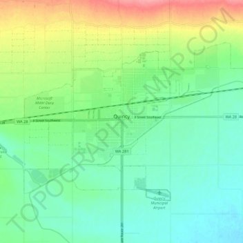
Name: Topografische Karte Quincy, Höhe, Relief.
Ort: Quincy, Grant County, Washington, United States (47.20901 -119.89663 47.25637 -119.78948)
Durchschnittliche Höhe: 400 m
Minimale Höhe: 373 m
Maximale Höhe: 458 m
Andere topografische Karten
Klicken Sie auf eine Karte, um ihre Topografie, ihre Höhe und ihr Relief anzuzeigen.
Grand Coulee
United States > Washington > Grant County
Grand Coulee, Grant County, Washington, 99133, United States
Durchschnittliche Höhe: 502 m
Trinidad
United States > Washington > Grant County > Trinidad
Trinidad, Grant County, Washington, United States
Durchschnittliche Höhe: 302 m
Moses Lake
United States > Washington > Grant County
Moses Lake, Grant County, Washington, 98837, United States
Durchschnittliche Höhe: 350 m