
Topografische Karte Moses Lake
Interaktive Karte
Klicken Sie auf die Karte, um die Höhe anzuzeigen.
Über diese Karte
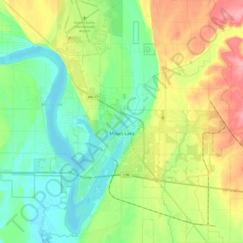
Name: Topografische Karte Moses Lake, Höhe, Relief.
Ort: Moses Lake, Grant County, Washington, 98837, United States (47.05708 -119.36364 47.21843 -119.17880)
Durchschnittliche Höhe: 350 m
Minimale Höhe: 314 m
Maximale Höhe: 416 m
Andere topografische Karten
Klicken Sie auf eine Karte, um ihre Topografie, ihre Höhe und ihr Relief anzuzeigen.
Quincy
United States > Washington > Grant County
Quincy, Grant County, Washington, United States
Durchschnittliche Höhe: 400 m
Grand Coulee
United States > Washington > Grant County
Grand Coulee, Grant County, Washington, 99133, United States
Durchschnittliche Höhe: 502 m
Trinidad
United States > Washington > Grant County > Trinidad
Trinidad, Grant County, Washington, United States
Durchschnittliche Höhe: 302 m