
Topografische Karte Town of Birdsall
Interaktive Karte
Klicken Sie auf die Karte, um die Höhe anzuzeigen.
Über diese Karte
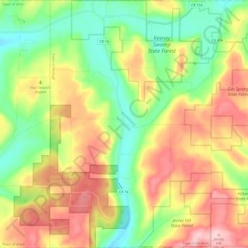
Name: Topografische Karte Town of Birdsall, Höhe, Relief.
Ort: Town of Birdsall, Allegany County, New York, United States (42.34757 -77.95622 42.43536 -77.83882)
Durchschnittliche Höhe: 581 m
Minimale Höhe: 489 m
Maximale Höhe: 687 m
Andere topografische Karten
Klicken Sie auf eine Karte, um ihre Topografie, ihre Höhe und ihr Relief anzuzeigen.
Town of Grove
United States > New York > Allegany County
Town of Grove, Allegany County, New York, 14884, United States
Durchschnittliche Höhe: 563 m
Village of Alfred
United States > New York > Allegany County
Village of Alfred, Town of Alfred, Allegany County, New York, 14802, United States
Durchschnittliche Höhe: 597 m
Town of Wellsville
United States > New York > Allegany County
Town of Wellsville, Allegany County, New York, 14895, United States
Durchschnittliche Höhe: 564 m
Village of Andover
United States > New York > Allegany County
Village of Andover, Town of Andover, Allegany County, New York, 14806, United States
Durchschnittliche Höhe: 561 m
Town of Rushford
United States > New York > Allegany County
Town of Rushford, Allegany County, New York, United States
Durchschnittliche Höhe: 528 m
Swain
United States > New York > Allegany County
Swain, Town of Grove, Allegany County, New York, 14884, United States
Durchschnittliche Höhe: 503 m
Almond
United States > New York > Allegany County > Almond
Almond, Allegany County, New York, United States
Durchschnittliche Höhe: 470 m
Birdsall
United States > New York > Allegany County
Birdsall, Town of Birdsall, Allegany County, New York, United States
Durchschnittliche Höhe: 582 m