
Topografische Karte Village of Alfred
Interaktive Karte
Klicken Sie auf die Karte, um die Höhe anzuzeigen.
Über diese Karte
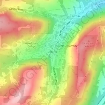
Name: Topografische Karte Village of Alfred, Höhe, Relief.
Durchschnittliche Höhe: 597 m
Minimale Höhe: 494 m
Maximale Höhe: 686 m
According to the United States Census Bureau, the village has a total area of 1.2 square miles (3.1 km2), all land. A small stream, Kanakadea Creek, flows through the center of the village, then to the Canisteo River, part of the Susquehanna River watershed. The topography is steep hill country, part of the Allegheny Plateau, a physiographic region that is part of the Appalachian Mountains.
Andere topografische Karten
Klicken Sie auf eine Karte, um ihre Topografie, ihre Höhe und ihr Relief anzuzeigen.
Town of Grove
United States > New York > Allegany County
Town of Grove, Allegany County, New York, 14884, United States
Durchschnittliche Höhe: 563 m
Town of Birdsall
United States > New York > Allegany County
Town of Birdsall, Allegany County, New York, United States
Durchschnittliche Höhe: 581 m
Town of Wellsville
United States > New York > Allegany County
Town of Wellsville, Allegany County, New York, 14895, United States
Durchschnittliche Höhe: 564 m
Village of Andover
United States > New York > Allegany County
Village of Andover, Town of Andover, Allegany County, New York, 14806, United States
Durchschnittliche Höhe: 561 m
Town of Rushford
United States > New York > Allegany County
Town of Rushford, Allegany County, New York, United States
Durchschnittliche Höhe: 528 m
Swain
United States > New York > Allegany County
Swain, Town of Grove, Allegany County, New York, 14884, United States
Durchschnittliche Höhe: 503 m
Almond
United States > New York > Allegany County > Almond
Almond, Allegany County, New York, United States
Durchschnittliche Höhe: 470 m
Birdsall
United States > New York > Allegany County
Birdsall, Town of Birdsall, Allegany County, New York, United States
Durchschnittliche Höhe: 582 m