
Topografische Karte West Linton
Interaktive Karte
Klicken Sie auf die Karte, um die Höhe anzuzeigen.
Über diese Karte
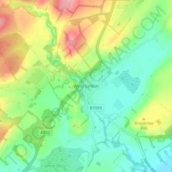
Name: Topografische Karte West Linton, Höhe, Relief.
Durchschnittliche Höhe: 264 m
Minimale Höhe: 213 m
Maximale Höhe: 355 m
Andere topografische Karten
Klicken Sie auf eine Karte, um ihre Topografie, ihre Höhe und ihr Relief anzuzeigen.
Stow
United Kingdom > Scotland > Scottish Borders
Stow, Scottish Borders, Scotland, TD1 2RE, United Kingdom
Durchschnittliche Höhe: 268 m
Blacklaw
United Kingdom > Scotland > Scottish Borders
Blacklaw, Scottish Borders, Scotland, ML12 6QR, United Kingdom
Durchschnittliche Höhe: 360 m
Abbey St. Bathans
United Kingdom > Scotland > Scottish Borders
Abbey St. Bathans, Scottish Borders, Scotland, TD11 3TX, United Kingdom
Durchschnittliche Höhe: 212 m
Cappercleuch
United Kingdom > Scotland > Scottish Borders
Cappercleuch, Scottish Borders, Scotland, TD7 5LG, United Kingdom
Durchschnittliche Höhe: 378 m
Roberton
United Kingdom > Scotland > Scottish Borders > Roberton
Roberton, Scottish Borders, Scotland, TD9 7LX, United Kingdom
Durchschnittliche Höhe: 244 m
Kelso
United Kingdom > Scotland > Scottish Borders
Kelso, Scottish Borders, Scotland, TD5 7HG, United Kingdom
Durchschnittliche Höhe: 79 m