
Topografische Karte Washington County
Interaktive Karte
Klicken Sie auf die Karte, um die Höhe anzuzeigen.
Über diese Karte
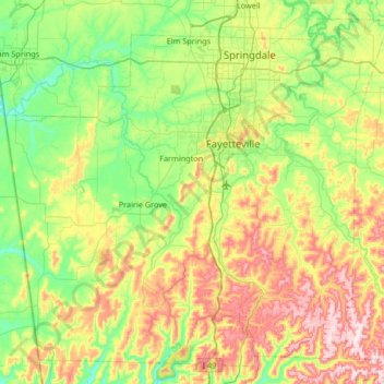
Name: Topografische Karte Washington County, Höhe, Relief.
Ort: Washington County, Arkansas, United States (35.75031 -94.55217 36.23824 -93.88827)
Durchschnittliche Höhe: 424 m
Minimale Höhe: 272 m
Maximale Höhe: 738 m
The economy of Washington County was based on apples in the late 19th century. A mixture of wet weather, altitude, and loamy soils provided a good environment for apple orchards. First planted in areas around Lincoln, Evansville, and Cane Hill in the 1830s, apple orchards began all across the county. The United States Census reported a crop of 614,924 bushels of apples produced by the county in 1900, the highest in the state. Several varieties of apple were discovered in the area including Shannon Pippin, Wilson June, and most notably the Arkansas Black. The Ben Davis became the apple of choice in the area for sale and shipment across the region. Corn became the dominant crop, outselling apples by almost $500,000 in 1900.
Andere topografische Karten
Klicken Sie auf eine Karte, um ihre Topografie, ihre Höhe und ihr Relief anzuzeigen.
Black Oak
United States > Arkansas > Washington County
Black Oak, Washington County, Arkansas, United States
Durchschnittliche Höhe: 427 m
Coulter Lake
United States > Arkansas > Pulaski County > Little Rock
Coulter Lake, Little Rock, Pulaski County, Arkansas, United States
Durchschnittliche Höhe: 100 m
Sherwood
United States > Arkansas > Pulaski County
Sherwood, Pulaski County, Arkansas, 72120, United States
Durchschnittliche Höhe: 108 m
McNeil
United States > Arkansas > Columbia County
McNeil, Columbia County, Arkansas, United States
Durchschnittliche Höhe: 105 m
Horseshoe Bend
United States > Arkansas > Izard County
Horseshoe Bend, Izard County, Arkansas, 72512, United States
Durchschnittliche Höhe: 216 m
Saint Claire
United States > Arkansas > Crittenden County
Saint Claire, Crittenden County, Arkansas, United States
Durchschnittliche Höhe: 66 m
Pine Bluff
United States > Arkansas > Jefferson County
Pine Bluff, Jefferson County, Arkansas, United States
Durchschnittliche Höhe: 69 m
Drasco
United States > Arkansas > Cleburne County
Drasco, Cleburne County, Arkansas, 72530, United States
Durchschnittliche Höhe: 309 m
Conway County
Conway County, Arkansas, United States
Durchschnittliche Höhe: 155 m
Garland County
Garland County, Arkansas, United States
Durchschnittliche Höhe: 224 m
Hot Spring County
Hot Spring County, Arkansas, United States
Durchschnittliche Höhe: 126 m
Mount Ida
United States > Arkansas > Montgomery County
Mount Ida, Montgomery County, Arkansas, United States
Durchschnittliche Höhe: 215 m
Norfork
United States > Arkansas > Baxter County
Norfork, Baxter County, Arkansas, 72658, United States
Durchschnittliche Höhe: 183 m
Ben Lomond
United States > Arkansas > Sevier County
Ben Lomond, Sevier County, Arkansas, 71823, United States
Durchschnittliche Höhe: 117 m
Cooper Point
United States > Arkansas > Stone County
Cooper Point, Stone County, Arkansas, 72560, United States
Durchschnittliche Höhe: 303 m
Brookland
United States > Arkansas > Craighead County
Brookland, Craighead County, Arkansas, 72417, United States
Durchschnittliche Höhe: 83 m
North Little Rock
United States > Arkansas > Pulaski County
North Little Rock, Pulaski County, Arkansas, United States
Durchschnittliche Höhe: 96 m
Rose City
United States > Arkansas > Pulaski County > North Little Rock
Rose City, North Little Rock, Pulaski County, Arkansas, 72117, United States
Durchschnittliche Höhe: 76 m
Wallaceburg
United States > Arkansas > Hempstead County
Wallaceburg, Hempstead County, Arkansas, 71825, United States
Durchschnittliche Höhe: 108 m
Huntsville
United States > Arkansas > Madison County
Huntsville, Madison County, Arkansas, United States
Durchschnittliche Höhe: 442 m
El Dorado
United States > Arkansas > Union County
El Dorado, Union County, Arkansas, United States
Durchschnittliche Höhe: 66 m
Maumelle
United States > Arkansas > Pulaski County
Maumelle, Pulaski County, Arkansas, 72113, United States
Durchschnittliche Höhe: 87 m
Lakeview
United States > Arkansas > Baxter County
Lakeview, Baxter County, Arkansas, 72642, United States
Durchschnittliche Höhe: 222 m
Mount Magazine State Park
United States > Arkansas > Logan County
Mount Magazine State Park, Signal Hill Trail, Logan County, Arkansas, United States
Durchschnittliche Höhe: 667 m
Parkdale
United States > Arkansas > Ashley County
Parkdale, Ashley County, Arkansas, United States
Durchschnittliche Höhe: 36 m
Jefferson County
Jefferson County, Arkansas, United States
Durchschnittliche Höhe: 68 m
Howard County
Howard County, Arkansas, United States
Durchschnittliche Höhe: 163 m
Pope County
Pope County, Arkansas, United States
Durchschnittliche Höhe: 252 m
Yell County
Yell County, Arkansas, United States
Durchschnittliche Höhe: 218 m
Decatur
United States > Arkansas > Benton County
Decatur, Benton County, Arkansas, 72722, United States
Durchschnittliche Höhe: 379 m
Greers Ferry
United States > Arkansas > Cleburne County
Greers Ferry, Cleburne County, Arkansas, 72067, United States
Durchschnittliche Höhe: 162 m
Thorn Crown Chapel
United States > Arkansas > Carroll County > Eureka Springs
Thorn Crown Chapel, US 62, Eureka Springs, Carroll County, Arkansas, 72631, United States
Durchschnittliche Höhe: 390 m
Wilmot
United States > Arkansas > Ashley County
Wilmot, Ashley County, Arkansas, United States
Durchschnittliche Höhe: 36 m
Willow Beach Lake Dam
United States > Arkansas > Pulaski County > North Little Rock
Willow Beach Lake Dam, North Little Rock, Pulaski County, Arkansas, 72142, United States
Durchschnittliche Höhe: 73 m
Yates Mountain
United States > Arkansas > Madison County
Yates Mountain, Madison County, Arkansas, 72742, United States
Durchschnittliche Höhe: 476 m
Egypt
United States > Arkansas > Craighead County
Egypt, Craighead County, Arkansas, 72427, United States
Durchschnittliche Höhe: 76 m
Eudora
United States > Arkansas > Chicot County
Eudora, Chicot County, Arkansas, 71640, United States
Durchschnittliche Höhe: 37 m
Carroll County
Carroll County, Arkansas, United States
Durchschnittliche Höhe: 423 m
Dagmar
United States > Arkansas > Monroe County
Dagmar, Monroe County, Arkansas, United States
Durchschnittliche Höhe: 52 m
Cherry Valley
United States > Arkansas > Cross County
Cherry Valley, Cross County, Arkansas, United States
Durchschnittliche Höhe: 87 m
Malvern
United States > Arkansas > Hot Spring County > Malvern
Malvern, Hot Spring County, Arkansas, 72104, United States
Durchschnittliche Höhe: 101 m
Fort Smith
United States > Arkansas > Sebastian County
Fort Smith, Sebastian County, Arkansas, United States
Durchschnittliche Höhe: 140 m
Horseshoe Lake
United States > Arkansas > Crittenden County
Horseshoe Lake, Crittenden County, Arkansas, 72348, United States
Durchschnittliche Höhe: 62 m
Fountain Lake
United States > Arkansas > Garland County > Fountain Lake
Fountain Lake, Garland County, Arkansas, 71901, United States
Durchschnittliche Höhe: 165 m
Beaver Lake
United States > Arkansas > Benton County > Goshen
Beaver Lake, Goshen, Benton County, Arkansas, 72757, United States
Durchschnittliche Höhe: 394 m
Stone County
United States > Arkansas > Stone County
Stone County, Arkansas, United States
Durchschnittliche Höhe: 268 m
Maumelle
United States > Arkansas > Pulaski County > Maumelle > Maumelle
Maumelle, Pulaski County, Arkansas, 72113, United States
Durchschnittliche Höhe: 88 m
Starkey Hill
United States > Arkansas > White County
Starkey Hill, White County, Arkansas, United States
Durchschnittliche Höhe: 215 m
Coler Creek
United States > Arkansas > Benton County > Bentonville
Coler Creek, Bentonville, Benton County, Arkansas, 72716, United States
Durchschnittliche Höhe: 371 m
White County
United States > Arkansas > White County
White County, Arkansas, United States
Durchschnittliche Höhe: 111 m