
Topografische Karte Bellamonte
Klicken Sie auf die Karte, um die Höhe anzuzeigen.
Über diese Karte
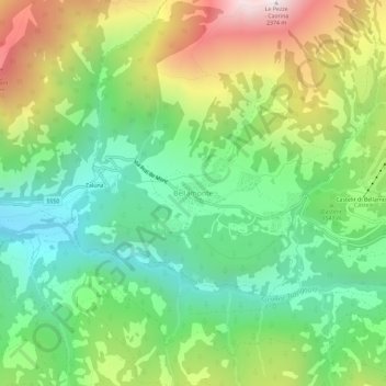
Name: Topografische Karte Bellamonte, Höhe, Relief.
Durchschnittliche Höhe: 1.547 m
Minimale Höhe: 1.076 m
Maximale Höhe: 2.356 m
Andere topografische Karten
Klicken Sie auf eine Karte, um ihre Topografie, ihre Höhe und ihr Relief anzuzeigen.
Latemar-Gruppe
Italien > Trentino-Südtirol > Autonome Provinz Trient
Die Ansicht des Latemarmassivs vom Karersee aus zählt zu den bekanntesten Landschaftsbildern der Dolomiten. Dennoch ist das Gebirge selbst nur wenig für den Tourismus erschlossen und zählt zu den einsamsten Gebirgsgruppen der Dolomiten. Ein Grund dafür ist das im Gegensatz zur benachbarten…
Durchschnittliche Höhe: 1.696 m