
Topografische Karte Port-Launay
Interaktive Karte
Klicken Sie auf die Karte, um die Höhe anzuzeigen.
Über diese Karte
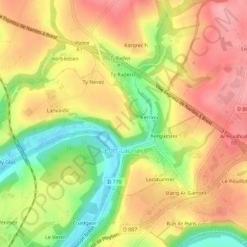
Name: Topografische Karte Port-Launay, Höhe, Relief.
Durchschnittliche Höhe: 67 m
Minimale Höhe: 1 m
Maximale Höhe: 115 m
Sa superficie est toute petite (2 km2), le finage communal étant limité à l'ouest par l'Aulne, et ne comprend en dehors du bourg, étiré le long de l'Aulne, que quelques hameaux (Lanvaïdic au nord, Roz Lezabennec à l'est). En dépit de sa petitesse, la commune possède un relief accidenté car la vallée de l'Aulne est très encaissée. si le bourg et les rives de l'Aulne se trouvent à 5 mètres d'altitude, celle-ci atteint 86 mètres près du hameau de Lanvaïdic et 72 mètres à Lezabennec, les deux hameaux étant séparés par un vallon affluent de l'Aulne lui-même très encaissé, emprunté par la D 48A. Seules deux communes sont limitrophes de Port-Launay. Châteaulin, qui l'enserre à l'est, au sud et à l'ouest (rive gauche de l'Aulne) et Saint-Ségal au nord.
Andere topografische Karten
Klicken Sie auf eine Karte, um ihre Topografie, ihre Höhe und ihr Relief anzuzeigen.
Douarnenez
Douarnenez, Quimper, Finistère, Bretagne, France métropolitaine, 29100, France
Durchschnittliche Höhe: 44 m
L'Aber Benoît
L'Aber Benoît, Finistère, Bretagne, France métropolitaine, France
Durchschnittliche Höhe: 64 m
Paroisse Sainte-Colomban en Pays de Quimperlé
Paroisse Sainte-Colomban en Pays de Quimperlé, Finistère, Bretagne, France métropolitaine, France
Durchschnittliche Höhe: 97 m
Roz ar Pillat
France > Bretagne > Finistère > Beuzec-Cap-Sizun
Roz ar Pillat, Beuzec-Cap-Sizun, Quimper, Finistère, Bretagne, France métropolitaine, 29790, France
Durchschnittliche Höhe: 58 m
Île-de-Batz
Île-de-Batz, Morlaix, Finistère, Bretagne, France métropolitaine, 29253, France
Durchschnittliche Höhe: 1 m
Pont-l'Abbé
Pont-l'Abbé, Quimper, Finistère, Bretagne, France métropolitaine, 29120, France
Durchschnittliche Höhe: 16 m
Les Pyrénées
France > Bretagne > Finistère > Briec
Les Pyrénées, Briec, Quimper, Finistère, Bretagne, France métropolitaine, 29510, France
Durchschnittliche Höhe: 154 m
La Laïta
France > Bretagne > Finistère > Clohars-Carnoët
La Laïta, Clohars-Carnoët, Quimper, Finistère, Bretagne, France métropolitaine, 29360, France
Durchschnittliche Höhe: 45 m
Cléden-Poher
Cléden-Poher, Châteaulin, Finistère, Bretagne, France métropolitaine, 29270, France
Durchschnittliche Höhe: 116 m
Résidence de Porzh al Leur
France > Bretagne > Finistère > Châteauneuf-du-Faou
Résidence de Porzh al Leur, Châteauneuf-du-Faou, Châteaulin, Finistère, Bretagne, France métropolitaine, 29520, France
Durchschnittliche Höhe: 101 m
Châteaulin
Châteaulin, Finistère, Bretagne, France métropolitaine, 29150, France
Durchschnittliche Höhe: 87 m
Sainte-Marguerite
France > Bretagne > Finistère > Riec-sur-Bélon
Sainte-Marguerite, Riec-sur-Bélon, Quimper, Finistère, Bretagne, France métropolitaine, 29340, France
Durchschnittliche Höhe: 53 m
Pen Pont Aven
France > Bretagne > Finistère > Pont-Aven
Pen Pont Aven, Pont-Aven, Quimper, Finistère, Bretagne, France métropolitaine, 29930, France
Durchschnittliche Höhe: 48 m
Penaros Créac'h Ar Zant
France > Bretagne > Finistère > Plougonven
Penaros Créac'h Ar Zant, Plougonven, Morlaix, Finistère, Bretagne, France métropolitaine, 29640, France
Durchschnittliche Höhe: 91 m
Plougasnou
Plougasnou, Morlaix, Finistère, Bretagne, France métropolitaine, 29630, France
Durchschnittliche Höhe: 59 m
Pen Ar C Hoat Keruzanval
France > Bretagne > Finistère > Guilers
Pen Ar C Hoat Keruzanval, Guilers, Brest, Finistère, Bretagne, France métropolitaine, 29820, France
Durchschnittliche Höhe: 75 m
Guerlesquin
France > Bretagne > Finistère > Guerlesquin
Guerlesquin, Morlaix, Finistère, Bretagne, France métropolitaine, 29650, France
Durchschnittliche Höhe: 208 m
Creach Manuel
France > Bretagne > Finistère > Plougonvelin
Creach Manuel, Plougonvelin, Brest, Finistère, Bretagne, France métropolitaine, 29217, France
Durchschnittliche Höhe: 29 m
Pointe Saint-Mathieu
France > Bretagne > Finistère > Plougonvelin > Saint-Mathieu
Pointe Saint-Mathieu, Saint-Mathieu, Plougonvelin, Brest, Finistère, Bretagne, France métropolitaine, 29217, France
Durchschnittliche Höhe: 8 m
Kerambellec
France > Bretagne > Finistère > Lanildut > Kerambellec
Kerambellec, Lanildut, Brest, Finistère, Bretagne, France métropolitaine, 29840, France
Durchschnittliche Höhe: 30 m
Moulin de Bel Air
France > Bretagne > Finistère > Brélès > Moulin de Bel Air
Moulin de Bel Air, Brélès, Brest, Finistère, Bretagne, France métropolitaine, 29810, France
Durchschnittliche Höhe: 40 m
Plounéour-Ménez
Plounéour-Ménez, Morlaix, Finistère, Bretagne, France métropolitaine, 29410, France
Durchschnittliche Höhe: 221 m
Saint-Urbain
Saint-Urbain, Brest, Finistère, Bretagne, France métropolitaine, 29800, France
Durchschnittliche Höhe: 94 m