
Topografische Karte Saint-Urbain
Interaktive Karte
Klicken Sie auf die Karte, um die Höhe anzuzeigen.
Über diese Karte
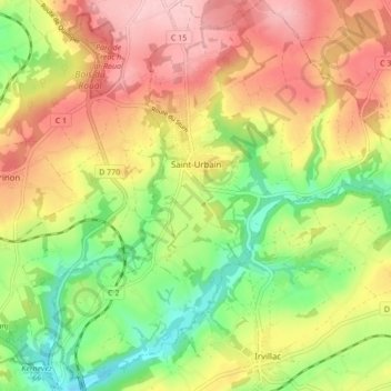
Name: Topografische Karte Saint-Urbain, Höhe, Relief.
Durchschnittliche Höhe: 94 m
Minimale Höhe: 6 m
Maximale Höhe: 182 m
La commune est très vallonnée, les altitudes au sein du finage communal allant de 2 mètres (au niveau du viaduc de chemin de fer, à la limite de Daoulas) à 178 mètres à l'est (plateau de Ploudiry), l'altitude moyenne étant de 90 mètres, même si le bourg se trouve vers 110 mètres d'altitude.
Andere topografische Karten
Klicken Sie auf eine Karte, um ihre Topografie, ihre Höhe und ihr Relief anzuzeigen.
Douarnenez
Douarnenez, Quimper, Finistère, Bretagne, France métropolitaine, 29100, France
Durchschnittliche Höhe: 44 m
L'Aber Benoît
L'Aber Benoît, Finistère, Bretagne, France métropolitaine, France
Durchschnittliche Höhe: 64 m
Paroisse Sainte-Colomban en Pays de Quimperlé
Paroisse Sainte-Colomban en Pays de Quimperlé, Finistère, Bretagne, France métropolitaine, France
Durchschnittliche Höhe: 97 m
Roz ar Pillat
France > Bretagne > Finistère > Beuzec-Cap-Sizun
Roz ar Pillat, Beuzec-Cap-Sizun, Quimper, Finistère, Bretagne, France métropolitaine, 29790, France
Durchschnittliche Höhe: 58 m
Île-de-Batz
Île-de-Batz, Morlaix, Finistère, Bretagne, France métropolitaine, 29253, France
Durchschnittliche Höhe: 1 m
Pont-l'Abbé
Pont-l'Abbé, Quimper, Finistère, Bretagne, France métropolitaine, 29120, France
Durchschnittliche Höhe: 16 m
Les Pyrénées
France > Bretagne > Finistère > Briec
Les Pyrénées, Briec, Quimper, Finistère, Bretagne, France métropolitaine, 29510, France
Durchschnittliche Höhe: 154 m
La Laïta
France > Bretagne > Finistère > Clohars-Carnoët
La Laïta, Clohars-Carnoët, Quimper, Finistère, Bretagne, France métropolitaine, 29360, France
Durchschnittliche Höhe: 45 m
Cléden-Poher
Cléden-Poher, Châteaulin, Finistère, Bretagne, France métropolitaine, 29270, France
Durchschnittliche Höhe: 116 m
Résidence de Porzh al Leur
France > Bretagne > Finistère > Châteauneuf-du-Faou
Résidence de Porzh al Leur, Châteauneuf-du-Faou, Châteaulin, Finistère, Bretagne, France métropolitaine, 29520, France
Durchschnittliche Höhe: 101 m
Châteaulin
Châteaulin, Finistère, Bretagne, France métropolitaine, 29150, France
Durchschnittliche Höhe: 87 m
Sainte-Marguerite
France > Bretagne > Finistère > Riec-sur-Bélon
Sainte-Marguerite, Riec-sur-Bélon, Quimper, Finistère, Bretagne, France métropolitaine, 29340, France
Durchschnittliche Höhe: 53 m
Pen Pont Aven
France > Bretagne > Finistère > Pont-Aven
Pen Pont Aven, Pont-Aven, Quimper, Finistère, Bretagne, France métropolitaine, 29930, France
Durchschnittliche Höhe: 48 m
Penaros Créac'h Ar Zant
France > Bretagne > Finistère > Plougonven
Penaros Créac'h Ar Zant, Plougonven, Morlaix, Finistère, Bretagne, France métropolitaine, 29640, France
Durchschnittliche Höhe: 91 m
Plougasnou
Plougasnou, Morlaix, Finistère, Bretagne, France métropolitaine, 29630, France
Durchschnittliche Höhe: 59 m
Pen Ar C Hoat Keruzanval
France > Bretagne > Finistère > Guilers
Pen Ar C Hoat Keruzanval, Guilers, Brest, Finistère, Bretagne, France métropolitaine, 29820, France
Durchschnittliche Höhe: 75 m
Guerlesquin
France > Bretagne > Finistère > Guerlesquin
Guerlesquin, Morlaix, Finistère, Bretagne, France métropolitaine, 29650, France
Durchschnittliche Höhe: 208 m
Creach Manuel
France > Bretagne > Finistère > Plougonvelin
Creach Manuel, Plougonvelin, Brest, Finistère, Bretagne, France métropolitaine, 29217, France
Durchschnittliche Höhe: 29 m
Pointe Saint-Mathieu
France > Bretagne > Finistère > Plougonvelin > Saint-Mathieu
Pointe Saint-Mathieu, Saint-Mathieu, Plougonvelin, Brest, Finistère, Bretagne, France métropolitaine, 29217, France
Durchschnittliche Höhe: 8 m
Kerambellec
France > Bretagne > Finistère > Lanildut > Kerambellec
Kerambellec, Lanildut, Brest, Finistère, Bretagne, France métropolitaine, 29840, France
Durchschnittliche Höhe: 30 m
Moulin de Bel Air
France > Bretagne > Finistère > Brélès > Moulin de Bel Air
Moulin de Bel Air, Brélès, Brest, Finistère, Bretagne, France métropolitaine, 29810, France
Durchschnittliche Höhe: 40 m
Plounéour-Ménez
Plounéour-Ménez, Morlaix, Finistère, Bretagne, France métropolitaine, 29410, France
Durchschnittliche Höhe: 221 m
Port-Launay
Port-Launay, Châteaulin, Finistère, Bretagne, France métropolitaine, 29150, France
Durchschnittliche Höhe: 67 m