
Topografische Karte Dedza
Interaktive Karte
Klicken Sie auf die Karte, um die Höhe anzuzeigen.
Über diese Karte
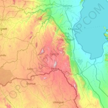
Name: Topografische Karte Dedza, Höhe, Relief.
Ort: Dedza, Central Region, Malawi, Malawi (-14.61663 33.65006 -13.85837 34.74269)
Durchschnittliche Höhe: 971 m
Minimale Höhe: 471 m
Maximale Höhe: 2.142 m
The western part of the district is on the Central African Plateau at an altitude of 1 200 to 1,600 m. Higher mountain ranges separate this from land alongside Lake Malawi in the Rift Valley at 500 m. The landscape is a mixture of grassland with granite outcrops, natural woodland and commercial pine plantations on the mountains and some bamboo forest nearer the lake. The wet season is November to April with almost no rainfall at other times. The higher altitudes have moderate temperatures and can be cold in June and July.
Andere topografische Karten
Klicken Sie auf eine Karte, um ihre Topografie, ihre Höhe und ihr Relief anzuzeigen.
Kasungu National Park
Kasungu National Park, Kasungu, Central Region, Malawi, Malawi
Durchschnittliche Höhe: 1.087 m
Nkhotakota
Malawi > Nkhotakota > Nkhotakota
Nkhotakota, Central Region, Malawi, Malawi
Durchschnittliche Höhe: 487 m
Uzumara Forest Reserve
Uzumara Forest Reserve, M1, Mojowa, Rumphi, Northern Region, Malawi
Durchschnittliche Höhe: 1.687 m
Lake Chilwa
Lake Chilwa, Zomba, Southern Region, Malawi
Durchschnittliche Höhe: 647 m