
Topografische Karte Nsanje
Interaktive Karte
Klicken Sie auf die Karte, um die Höhe anzuzeigen.
Über diese Karte
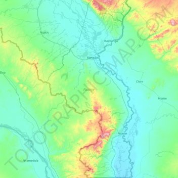
Name: Topografische Karte Nsanje, Höhe, Relief.
Ort: Nsanje, Southern Region, Malawi, Malawi (-17.12960 34.89497 -16.31016 35.31473)
Durchschnittliche Höhe: 172 m
Minimale Höhe: 31 m
Maximale Höhe: 965 m
Nsanje is the southernmost district in Malawi and lies in the Lower Shire River Valley. It straddles the Shire River in the north (the river forms most of Nsanje's eastern boundary) and is surrounded by Mozambique. Elevation is around 200 feet (61 m) ASL except for some hills in the south-western part of the district which reach near to 2,000 feet (610 m) ASL. Mwabvi Game Reserve lies in the north-western part of the district and can be accessed from Bangula or Sorgin (both along the M-1 road) Elephant Marsh lies partially in the northern part of the district and can be accessed for tours via the eastern bank road. Tours start from the village of James.
Andere topografische Karten
Klicken Sie auf eine Karte, um ihre Topografie, ihre Höhe und ihr Relief anzuzeigen.
Kasungu National Park
Kasungu National Park, Kasungu, Central Region, Malawi, Malawi
Durchschnittliche Höhe: 1.087 m
Nkhotakota
Malawi > Nkhotakota > Nkhotakota
Nkhotakota, Central Region, Malawi, Malawi
Durchschnittliche Höhe: 487 m
Uzumara Forest Reserve
Uzumara Forest Reserve, M1, Mojowa, Rumphi, Northern Region, Malawi
Durchschnittliche Höhe: 1.687 m
Lake Chilwa
Lake Chilwa, Zomba, Southern Region, Malawi
Durchschnittliche Höhe: 647 m