
Topografische Karte Hollis
Interaktive Karte
Klicken Sie auf die Karte, um die Höhe anzuzeigen.
Über diese Karte
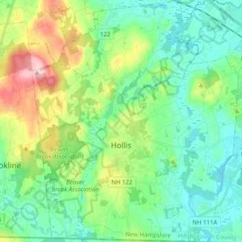
Name: Topografische Karte Hollis, Höhe, Relief.
Ort: Hollis, Hillsborough County, New Hampshire, United States (42.70280 -71.64186 42.80359 -71.52490)
Durchschnittliche Höhe: 101 m
Minimale Höhe: 46 m
Maximale Höhe: 246 m
Andere topografische Karten
Klicken Sie auf eine Karte, um ihre Topografie, ihre Höhe und ihr Relief anzuzeigen.
Thorntons Ferry
United States > New Hampshire > Hillsborough County > Merrimack
Thorntons Ferry, Merrimack, Hillsborough County, New Hampshire, 03054, United States
Durchschnittliche Höhe: 54 m
Manchester
United States > New Hampshire > Hillsborough County
Manchester, Hillsborough County, New Hampshire, United States
Durchschnittliche Höhe: 96 m
Amherst
United States > New Hampshire > Hillsborough County > Amherst
Amherst, Hillsborough County, New Hampshire, 03031, United States
Durchschnittliche Höhe: 127 m
Nashua
United States > New Hampshire > Hillsborough County > Nashua
Nashua, Hillsborough County, New Hampshire, 03060-03064, United States
Durchschnittliche Höhe: 82 m
Nashua
United States > New Hampshire > Hillsborough County
Nashua, Hillsborough County, New Hampshire, United States
Durchschnittliche Höhe: 62 m