
Topografische Karte Manchester
Interaktive Karte
Klicken Sie auf die Karte, um die Höhe anzuzeigen.
Über diese Karte
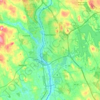
Name: Topografische Karte Manchester, Höhe, Relief.
Durchschnittliche Höhe: 96 m
Minimale Höhe: 32 m
Maximale Höhe: 245 m
According to the United States Census Bureau, the city has a total area of 34.9 square miles (90.5 km2), of which 33.1 square miles (85.7 km2) are land and 1.9 square miles (4.8 km2) are water, comprising 5.33% of the city. Manchester is drained by the Merrimack River and its tributaries the Piscataquog River and Cohas Brook. Massabesic Lake is on the eastern border. The highest point in Manchester is atop Wellington Hill, where the elevation reaches 570 feet (170 m) above sea level.
Andere topografische Karten
Klicken Sie auf eine Karte, um ihre Topografie, ihre Höhe und ihr Relief anzuzeigen.
Thorntons Ferry
United States > New Hampshire > Hillsborough County > Merrimack
Thorntons Ferry, Merrimack, Hillsborough County, New Hampshire, 03054, United States
Durchschnittliche Höhe: 54 m
Hollis
United States > New Hampshire > Hillsborough County
Hollis, Hillsborough County, New Hampshire, United States
Durchschnittliche Höhe: 101 m
Amherst
United States > New Hampshire > Hillsborough County > Amherst
Amherst, Hillsborough County, New Hampshire, 03031, United States
Durchschnittliche Höhe: 127 m
Nashua
United States > New Hampshire > Hillsborough County > Nashua
Nashua, Hillsborough County, New Hampshire, 03060-03064, United States
Durchschnittliche Höhe: 82 m
Nashua
United States > New Hampshire > Hillsborough County
Nashua, Hillsborough County, New Hampshire, United States
Durchschnittliche Höhe: 62 m