
Spenden
Rüste dich für dein nächstes Abenteuer:
Als Amazon-Partner verdient diese Website an qualifizierten Käufen, ohne zusätzliche Kosten für Sie.
Topografische Karte Newtown Linford
Klicken Sie auf die Karte, um die Höhe anzuzeigen.
Spenden
Rüste dich für dein nächstes Abenteuer:
Als Amazon-Partner verdient diese Website an qualifizierten Käufen, ohne zusätzliche Kosten für Sie.
Über diese Karte
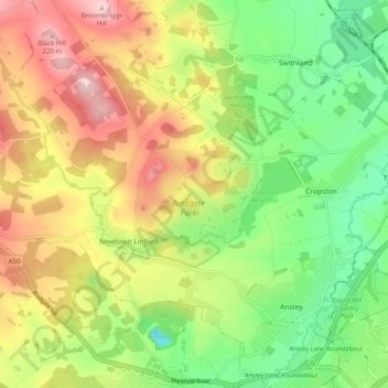
Name: Topografische Karte Newtown Linford, Höhe, Relief.
Durchschnittliche Höhe: 115 m
Minimale Höhe: 18 m
Maximale Höhe: 234 m
Spenden
Rüste dich für dein nächstes Abenteuer:
Als Amazon-Partner verdient diese Website an qualifizierten Käufen, ohne zusätzliche Kosten für Sie.
Andere topografische Karten
Klicken Sie auf eine Karte, um ihre Topografie, ihre Höhe und ihr Relief anzuzeigen.
Watermead Country Park
United Kingdom > England > Leicestershire > Charnwood > Birstall
Durchschnittliche Höhe: 59 m
Spenden
Rüste dich für dein nächstes Abenteuer:
Als Amazon-Partner verdient diese Website an qualifizierten Käufen, ohne zusätzliche Kosten für Sie.
Bradgate Park
United Kingdom > England > Leicestershire > Charnwood > Newtown Linford
Overlying the Beacon Hill Formation, but found a little further down the hillside to the south, are the Bradgate Formation beds, the most notable of which is the Sliding Stone Slump Breccia rocks. Forming a line of crags below Old John, these are laminated mudstones, with layers of sandstone, mainly of…
Durchschnittliche Höhe: 126 m
Moat Hill Spinney
United Kingdom > England > Leicestershire > Charnwood > Cotes
Durchschnittliche Höhe: 50 m
Spenden
Rüste dich für dein nächstes Abenteuer:
Als Amazon-Partner verdient diese Website an qualifizierten Käufen, ohne zusätzliche Kosten für Sie.
Lea Wood
United Kingdom > England > Leicestershire > Charnwood > Newtown Linford
Durchschnittliche Höhe: 170 m
Lower Moor
United Kingdom > England > Leicestershire > Charnwood > Cossington
Durchschnittliche Höhe: 53 m
Spenden
Rüste dich für dein nächstes Abenteuer:
Als Amazon-Partner verdient diese Website an qualifizierten Käufen, ohne zusätzliche Kosten für Sie.
Old John
United Kingdom > England > Leicestershire > Charnwood > Newtown Linford
Durchschnittliche Höhe: 143 m
Six Hills
United Kingdom > England > Leicestershire > Charnwood > Burton on the Wolds
Durchschnittliche Höhe: 128 m
Spenden
Rüste dich für dein nächstes Abenteuer:
Als Amazon-Partner verdient diese Website an qualifizierten Käufen, ohne zusätzliche Kosten für Sie.
Swithland Wood
United Kingdom > England > Leicestershire > Charnwood > Swithland
Durchschnittliche Höhe: 107 m
Beacon Hill Country Park
United Kingdom > England > Leicestershire > Charnwood > Woodhouse Eaves
Durchschnittliche Höhe: 164 m
Spenden
Rüste dich für dein nächstes Abenteuer:
Als Amazon-Partner verdient diese Website an qualifizierten Käufen, ohne zusätzliche Kosten für Sie.
Stanford Park
United Kingdom > England > Leicestershire > Charnwood > Hoton
Durchschnittliche Höhe: 69 m
Top Town Plantation
United Kingdom > England > Leicestershire > Charnwood > Walton on the Wolds
Durchschnittliche Höhe: 85 m
Spenden
Rüste dich für dein nächstes Abenteuer:
Als Amazon-Partner verdient diese Website an qualifizierten Käufen, ohne zusätzliche Kosten für Sie.