
Topografische Karte Quorn
Klicken Sie auf die Karte, um die Höhe anzuzeigen.
Über diese Karte
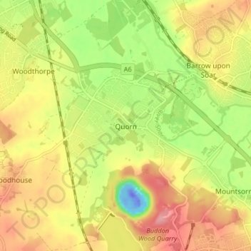
Name: Topografische Karte Quorn, Höhe, Relief.
Durchschnittliche Höhe: 55 m
Minimale Höhe: -59 m
Maximale Höhe: 102 m
Andere topografische Karten
Klicken Sie auf eine Karte, um ihre Topografie, ihre Höhe und ihr Relief anzuzeigen.
Barrow upon Soar
United Kingdom > England > Leicestershire > Charnwood > Barrow upon Soar
Durchschnittliche Höhe: 62 m
Bradgate Park
United Kingdom > England > Leicestershire > Charnwood > Newtown Linford
Overlying the Beacon Hill Formation, but found a little further down the hillside to the south, are the Bradgate Formation beds, the most notable of which is the Sliding Stone Slump Breccia rocks. Forming a line of crags below Old John, these are laminated mudstones, with layers of sandstone, mainly of…
Durchschnittliche Höhe: 126 m
Swithland Wood
United Kingdom > England > Leicestershire > Charnwood > Swithland
Durchschnittliche Höhe: 107 m
Watermead Country Park
United Kingdom > England > Leicestershire > Charnwood > Birstall
Durchschnittliche Höhe: 59 m
South Croxton
United Kingdom > England > Leicestershire > Charnwood > South Croxton
The highest point is the church, at 120 m above mean sea level. The lowest altitude is 85 m by the Queniborough Brook.
Durchschnittliche Höhe: 108 m
Queniborough
United Kingdom > England > Leicestershire > Charnwood > Queniborough
Durchschnittliche Höhe: 75 m
Beeby
United Kingdom > England > Leicestershire > Charnwood
The physical and historical development of the hamlet has been strongly influenced by the local topography and its relative isolation. Beeby is situated within an established agricultural landscape largely in pastoral use. Until 1904 the east-west route was the only route through the hamlet, which was referred…
Durchschnittliche Höhe: 101 m
Stanford Park
United Kingdom > England > Leicestershire > Charnwood > Hoton
Durchschnittliche Höhe: 69 m
Top Town Plantation
United Kingdom > England > Leicestershire > Charnwood > Walton on the Wolds
Durchschnittliche Höhe: 85 m
Shepshed
United Kingdom > England > Leicestershire > Charnwood > Shepshed
Durchschnittliche Höhe: 111 m
Mountsorrel
United Kingdom > England > Leicestershire > Charnwood > Mountsorrel
Durchschnittliche Höhe: 57 m
Moat Hill Spinney
United Kingdom > England > Leicestershire > Charnwood > Cotes
Durchschnittliche Höhe: 50 m
Lea Wood
United Kingdom > England > Leicestershire > Charnwood > Newtown Linford
Durchschnittliche Höhe: 170 m
Charnwood Water
United Kingdom > England > Leicestershire > Charnwood > Woodthorpe
Durchschnittliche Höhe: 47 m
Thurmaston
United Kingdom > England > Leicestershire > Charnwood > Thurmaston
Durchschnittliche Höhe: 62 m
Ratcliffe on the Wreake
United Kingdom > England > Leicestershire > Charnwood
Durchschnittliche Höhe: 69 m
Swithland
United Kingdom > England > Leicestershire > Charnwood > Swithland
Durchschnittliche Höhe: 74 m
Burton on the Wolds
United Kingdom > England > Leicestershire > Charnwood
Durchschnittliche Höhe: 78 m
East Goscote
United Kingdom > England > Leicestershire > Charnwood > East Goscote
Durchschnittliche Höhe: 61 m
Cossington
United Kingdom > England > Leicestershire > Charnwood > Syston
Durchschnittliche Höhe: 61 m
Beacon Hill Country Park
United Kingdom > England > Leicestershire > Charnwood > Woodhouse Eaves
Durchschnittliche Höhe: 164 m
Seagrave
United Kingdom > England > Leicestershire > Charnwood > Seagrave
Durchschnittliche Höhe: 98 m
Barrow upon Soar
United Kingdom > England > Leicestershire > Charnwood > Barrow upon Soar
Durchschnittliche Höhe: 62 m
Thurmaston
United Kingdom > England > Leicestershire > Charnwood > Thurmaston
Durchschnittliche Höhe: 62 m
Cossington
United Kingdom > England > Leicestershire > Charnwood > Syston
Durchschnittliche Höhe: 61 m
Mammoth Lake
United Kingdom > England > Leicestershire > Charnwood > Thurmaston
Durchschnittliche Höhe: 58 m