
Topografische Karte Priest River
Interaktive Karte
Klicken Sie auf die Karte, um die Höhe anzuzeigen.
Über diese Karte
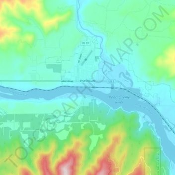
Name: Topografische Karte Priest River, Höhe, Relief.
Ort: Priest River, Bonner County, Idaho, United States (48.15520 -116.93702 48.20030 -116.82294)
Durchschnittliche Höhe: 742 m
Minimale Höhe: 624 m
Maximale Höhe: 1.171 m
Priest River is located at 48°11′0″N 116°54′34″W / 48.18333°N 116.90944°W / 48.18333; -116.90944 (48.183388, -116.909555), at an elevation of 2,139 feet (652 m) above sea level.
Andere topografische Karten
Klicken Sie auf eine Karte, um ihre Topografie, ihre Höhe und ihr Relief anzuzeigen.
Blanchard
United States > Idaho > Bonner County
Blanchard, Bonner County, Idaho, 83804, United States
Durchschnittliche Höhe: 718 m
Lake Pend Oreille
United States > Idaho > Bonner County
Lake Pend Oreille, Bonner County, Idaho, United States
Durchschnittliche Höhe: 941 m
Sandpoint
United States > Idaho > Bonner County
Sandpoint, Bonner County, Idaho, United States
Durchschnittliche Höhe: 658 m
East Hope
United States > Idaho > Bonner County > East Hope
East Hope, Bonner County, Idaho, United States
Durchschnittliche Höhe: 710 m
Clark Fork
United States > Idaho > Bonner County
Clark Fork, Bonner County, Idaho, United States
Durchschnittliche Höhe: 681 m