
Topografische Karte Blanchard
Interaktive Karte
Klicken Sie auf die Karte, um die Höhe anzuzeigen.
Über diese Karte
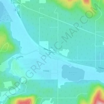
Name: Topografische Karte Blanchard, Höhe, Relief.
Ort: Blanchard, Bonner County, Idaho, 83804, United States (47.99685 -117.00381 48.03685 -116.96381)
Durchschnittliche Höhe: 718 m
Minimale Höhe: 682 m
Maximale Höhe: 912 m
Andere topografische Karten
Klicken Sie auf eine Karte, um ihre Topografie, ihre Höhe und ihr Relief anzuzeigen.
Priest River
United States > Idaho > Bonner County
Priest River, Bonner County, Idaho, United States
Durchschnittliche Höhe: 742 m
Lake Pend Oreille
United States > Idaho > Bonner County
Lake Pend Oreille, Bonner County, Idaho, United States
Durchschnittliche Höhe: 941 m
Sandpoint
United States > Idaho > Bonner County
Sandpoint, Bonner County, Idaho, United States
Durchschnittliche Höhe: 658 m
East Hope
United States > Idaho > Bonner County > East Hope
East Hope, Bonner County, Idaho, United States
Durchschnittliche Höhe: 710 m
Clark Fork
United States > Idaho > Bonner County
Clark Fork, Bonner County, Idaho, United States
Durchschnittliche Höhe: 681 m