
Topografische Karte Amsterdam
Interaktive Karte
Klicken Sie auf die Karte, um die Höhe anzuzeigen.
Über diese Karte
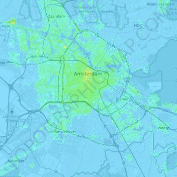
Name: Topografische Karte Amsterdam, Höhe, Relief.
Ort: Amsterdam, Noord-Holland, Nederland (52.27817 4.72876 52.43106 5.07916)
Durchschnittliche Höhe: 0 m
Minimale Höhe: -8 m
Maximale Höhe: 18 m
Topografisch kaartbeeld van de gemeente Amsterdam, per december 2016
Andere topografische Karten
Klicken Sie auf eine Karte, um ihre Topografie, ihre Höhe und ihr Relief anzuzeigen.
Amsterdam
Nederland > Noord-Holland > Amsterdam
Amsterdam, Noord-Holland, Nederland, 1012JS, Nederland
Durchschnittliche Höhe: -1 m
Zunderdorp
Nederland > Noord-Holland > Amsterdam
Zunderdorp, Amsterdam, Noord-Holland, Nederland, 1027 AP, Nederland
Durchschnittliche Höhe: -1 m
Schellingwoude
Nederland > Noord-Holland > Amsterdam
Schellingwoude, Amsterdam, Noord-Holland, Nederland, 1023 NH, Nederland
Durchschnittliche Höhe: 1 m
Rembrandtpark
Nederland > Noord-Holland > Amsterdam
Rembrandtpark, West, Amsterdam, Noord-Holland, Nederland
Durchschnittliche Höhe: 4 m
Ransdorp
Nederland > Noord-Holland > Amsterdam > Ransdorp
Ransdorp, Amsterdam, Noord-Holland, Nederland, 1028, Nederland
Durchschnittliche Höhe: -1 m
Kaap Oost
Nederland > Noord-Holland > Amsterdam
Kaap Oost, Amsterdam, Noord-Holland, Nederland
Durchschnittliche Höhe: 0 m