
Topografische Karte Chanthaburi Province
Interaktive Karte
Klicken Sie auf die Karte, um die Höhe anzuzeigen.
Über diese Karte
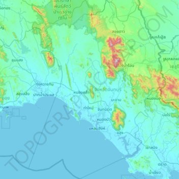
Name: Topografische Karte Chanthaburi Province, Höhe, Relief.
Ort: Chanthaburi Province, Thailand (12.14743 101.59858 13.33607 102.53589)
Durchschnittliche Höhe: 96 m
Minimale Höhe: -1 m
Maximale Höhe: 1.596 m
While the southern part of the province is on the shore of the Gulf of Thailand and thus is mostly coastal alluvial plains, the interior of the province is mountainous. The Chanthaburi Mountains in the north has the highest elevation in the province, the 1,675 m high Khao Soi Dao Tai peak. The main river of the province is the Chanthaburi River. The total forest area is 2,076 km2 (802 sq mi) or 32.4 percent of provincial area. Together with the neighboring province, Trat, Chanthaburi is a center of gemstone mining, especially rubies and sapphires. Tropical fruits are also among the main products of the province. In 2000, it produced nearly 380,000 tonnes of durian, which was 45.57 percent of Thailand's durian production, approximately 27 percent of the entire world's production.
Andere topografische Karten
Klicken Sie auf eine Karte, um ihre Topografie, ihre Höhe und ihr Relief anzuzeigen.
Surat Thani
Thailand > Surat Thani Province
Surat Thani, Wat Pradu, Surat Thani Province, 84000, Thailand
Durchschnittliche Höhe: 10 m
Pa Tong
Thailand > Phuket Province > Kathu > Patong
Pa Tong, Patong, Kathu, Phuket Province, 83150, Thailand
Durchschnittliche Höhe: 100 m
Baan Thong Krut
Thailand > Surat Thani Province
Baan Thong Krut, Surat Thani Province, 84010, Thailand
Durchschnittliche Höhe: 38 m
Kraburi River
Kraburi River, Ranong Province, Thailand
Durchschnittliche Höhe: 50 m
Lampang
Lampang, Ton Thong Chai, Lampang Province, 14001, Thailand
Durchschnittliche Höhe: 293 m
Ko Pha Ngan
Thailand > Surat Thani Province
Ko Pha Ngan, Surat Thani Province, Thailand
Durchschnittliche Höhe: 84 m
Ban Ton Pho
Thailand > Pathum Thani Province > Suan Phrik Thai Subdistrict Administrative Organization > Suan Phrik Thai Subdistrict
Ban Ton Pho, Suan Phrik Thai Subdistrict, Suan Phrik Thai Subdistrict Administrative Organization, Mueang Pathum Thani District, Pathum Thani Province, 12160, Thailand
Durchschnittliche Höhe: 4 m
Maha Sarakham
Thailand > Maha Sarakham Province
Maha Sarakham, Waeng Nang, Maha Sarakham Province, 44000, Thailand
Durchschnittliche Höhe: 146 m
Ban Chao Fa
Thailand > Ban Mai Rimthang Mu 6
Ban Chao Fa, Ban Mai Rimthang Mu 6, San Phak Wan, Saraphi District, 50230, Thailand
Durchschnittliche Höhe: 311 m
Tapi River
Thailand > Surat Thani Province
Tapi River, Surat Thani Province, Thailand
Durchschnittliche Höhe: 123 m
Ban Yai Ka Ta
Thailand > Phra Nakhon Si Ayutthaya Province > Uthai Subdistrict Administrative Organization > Uthai Subdistrict
Ban Yai Ka Ta, Uthai Subdistrict, Uthai Subdistrict Administrative Organization, Uthai District, Phra Nakhon Si Ayutthaya Province, 13210, Thailand
Durchschnittliche Höhe: 4 m
Laem Chabang
Laem Chabang, Takhian Tia, Chon Buri Province, 20230, Thailand
Durchschnittliche Höhe: 38 m
Ko Kut
Thailand > Trat Province > Ao Ta Nin
Ko Kut, Ao Ta Nin, Trat Province, Thailand
Durchschnittliche Höhe: 25 m
Ban Thung Setthi
Thailand > Kamphaeng Phet Province
Ban Thung Setthi, Nong Pling, Kamphaeng Phet Province, 62000, Thailand
Durchschnittliche Höhe: 80 m
Phetchabun
Thailand > Phetchabun Province
Phetchabun, Phetchabun Province, 67000, Thailand
Durchschnittliche Höhe: 120 m
Saraburi
Saraburi, Takut, Saraburi Province, 18000, Thailand
Durchschnittliche Höhe: 22 m
Buri Ram
Buri Ram, Isan, Buri Ram Province, 31009, Thailand
Durchschnittliche Höhe: 160 m