
Topografische Karte Village of Alexandria Bay
Interaktive Karte
Klicken Sie auf die Karte, um die Höhe anzuzeigen.
Über diese Karte
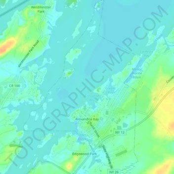
Name: Topografische Karte Village of Alexandria Bay, Höhe, Relief.
Durchschnittliche Höhe: 80 m
Minimale Höhe: 71 m
Maximale Höhe: 106 m
Andere topografische Karten
Klicken Sie auf eine Karte, um ihre Topografie, ihre Höhe und ihr Relief anzuzeigen.
City of Watertown
United States > New York > Jefferson County
City of Watertown, Jefferson County, New York, 13601, United States
Durchschnittliche Höhe: 150 m
Village of Adams
United States > New York > Jefferson County > Town of Adams
Village of Adams, Town of Adams, Jefferson County, New York, United States
Durchschnittliche Höhe: 189 m
Thousand Islands
United States > New York > Jefferson County
Thousand Islands, Town of Orleans, Jefferson County, New York, 13640, United States
Durchschnittliche Höhe: 111 m
Fort Drum
United States > New York > Jefferson County
Fort Drum, Town of Le Ray, Jefferson County, New York, United States
Durchschnittliche Höhe: 174 m
Village of Black River
United States > New York > Jefferson County
Village of Black River, Town of Le Ray, Jefferson County, New York, United States
Durchschnittliche Höhe: 193 m