
Topografische Karte City of Watertown
Interaktive Karte
Klicken Sie auf die Karte, um die Höhe anzuzeigen.
Über diese Karte
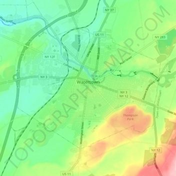
Name: Topografische Karte City of Watertown, Höhe, Relief.
Durchschnittliche Höhe: 150 m
Minimale Höhe: 93 m
Maximale Höhe: 261 m
Watertown is around 60 miles (97 kilometers) northwest of Syracuse, 20 miles (32 kilometers) south of the Thousand Islands and 328 miles (530 kilometers) northwest of New York City. According to the United States Census Bureau, the city has a total area of 9.3 square miles (24 km2), of which 9.0 square miles (23 km2) are land and 0.3 square miles (0.78 km2) (3.45 percent) is water. Before the area was settled, all the land was rough and forested. Elevation was also a problem. The Black River, flowing westward through the city toward Lake Ontario, is a world-renowned kayaking destination. Competition-level kayaking events, such as the Blackwater Challenge, have been held on the river.
Andere topografische Karten
Klicken Sie auf eine Karte, um ihre Topografie, ihre Höhe und ihr Relief anzuzeigen.
Village of Adams
United States > New York > Jefferson County > Town of Adams
Village of Adams, Town of Adams, Jefferson County, New York, United States
Durchschnittliche Höhe: 189 m
Village of Alexandria Bay
United States > New York > Jefferson County
Village of Alexandria Bay, Town of Alexandria, Jefferson County, New York, United States
Durchschnittliche Höhe: 80 m
Thousand Islands
United States > New York > Jefferson County
Thousand Islands, Town of Orleans, Jefferson County, New York, 13640, United States
Durchschnittliche Höhe: 111 m
Fort Drum
United States > New York > Jefferson County
Fort Drum, Town of Le Ray, Jefferson County, New York, United States
Durchschnittliche Höhe: 174 m
Village of Black River
United States > New York > Jefferson County
Village of Black River, Town of Le Ray, Jefferson County, New York, United States
Durchschnittliche Höhe: 193 m