
Topografische Karte Tonasket
Interaktive Karte
Klicken Sie auf die Karte, um die Höhe anzuzeigen.
Über diese Karte
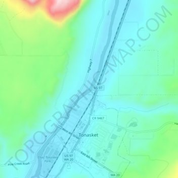
Name: Topografische Karte Tonasket, Höhe, Relief.
Durchschnittliche Höhe: 343 m
Minimale Höhe: 267 m
Maximale Höhe: 627 m
Tonasket is located along the Okanogan River at an altitude of 1,311 ft (400 m).
Andere topografische Karten
Klicken Sie auf eine Karte, um ihre Topografie, ihre Höhe und ihr Relief anzuzeigen.
Cathedral Peak
United States > Washington > Okanogan County
Cathedral Peak, Okanogan County, Washington, United States
Durchschnittliche Höhe: 2.231 m
Oroville
United States > Washington > Okanogan County > Oroville > Oroville
Oroville, Okanogan County, Washington, 98844-9372, United States
Durchschnittliche Höhe: 475 m
Seatons Grove
United States > Washington > Okanogan County
Seatons Grove, Okanogan County, Washington, 99124, United States
Durchschnittliche Höhe: 464 m